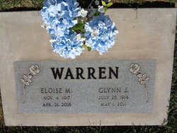
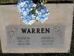
Eloise Twilite Mayberry Warren
| Birth | : | 4 Nov 1917 |
| Death | : | 21 Apr 2016 |
| Burial | : | Santa Clara Memorial Park, Lincoln, Placer County, USA |
| Coordinate | : | 38.8894710, -121.3260560 |
| Plot | : | Sec. MD, Lot 8, Grave W |
| Description | : | Eloise Twilite Mayberry Warren of Lincoln, Calif, passed away on April 21, 2016. She was born in Wiota, on Nov. 4, 1917, the daughter of Caple and Ester Felt Mayberry. She graduated from Atlantic High School in 1935. She married Glynn James Warren on Jan. 23, 1938 in Savannah, Mo. Eloise taught school until she married Glynn and continued her teaching skills with the Sunday School Classes at the United Methodist Church. She represented District Nine for the Iowa Farm Bureau Women, and continued to be active in Farm Bureau when they moved to San Luis Obispo where they resided for... Read More |
frequently asked questions (FAQ):
-
Where is Eloise Twilite Mayberry Warren's memorial?
Eloise Twilite Mayberry Warren's memorial is located at: Santa Clara Memorial Park, Lincoln, Placer County, USA.
-
When did Eloise Twilite Mayberry Warren death?
Eloise Twilite Mayberry Warren death on 21 Apr 2016 in
-
Where are the coordinates of the Eloise Twilite Mayberry Warren's memorial?
Latitude: 38.8894710
Longitude: -121.3260560
Family Members:
Flowers:
Nearby Cemetories:
1. Santa Clara Memorial Park
Lincoln, Placer County, USA
Coordinate: 38.8894710, -121.3260560
2. Lincoln Cemetery
Lincoln, Placer County, USA
Coordinate: 38.8864310, -121.3020500
3. Manzanita Cemetery
Lincoln, Placer County, USA
Coordinate: 38.9444008, -121.3032990
4. Morgan Oaks Eternal Preserve
Lincoln, Placer County, USA
Coordinate: 38.9629050, -121.2860530
5. Whitney Family Mausoleum
Rocklin, Placer County, USA
Coordinate: 38.8256500, -121.2477000
6. Sheridan Cemetery
Sheridan, Placer County, USA
Coordinate: 38.9741000, -121.3585300
7. School House Park Cemetery
Roseville, Placer County, USA
Coordinate: 38.7893180, -121.3578670
8. Gold Hill Cemetery
Gold Hill, Placer County, USA
Coordinate: 38.9025000, -121.1802200
9. Rocklin Cemetery
Rocklin, Placer County, USA
Coordinate: 38.7827670, -121.2337980
10. Roseville Public Cemetery District
Roseville, Placer County, USA
Coordinate: 38.7606010, -121.2707977
11. Boothill Cemetery
Roseville, Placer County, USA
Coordinate: 38.7598730, -121.2712130
12. Newcastle Cemetery
Newcastle, Placer County, USA
Coordinate: 38.8708880, -121.1444060
13. Shepherd of the Sierra Memorial Garden
Loomis, Placer County, USA
Coordinate: 38.7890800, -121.1944200
14. Stewarts Flat Cemetery
Penryn, Placer County, USA
Coordinate: 38.8447360, -121.1507950
15. Wheatland Cemetery
Wheatland, Yuba County, USA
Coordinate: 39.0083008, -121.4360962
16. Camp Far West Cemetery
Wheatland, Yuba County, USA
Coordinate: 39.0395500, -121.3431400
17. Ophir Cemetery
Placer County, USA
Coordinate: 38.8928870, -121.1273790
18. Fairview Cemetery
Rio Oso, Sutter County, USA
Coordinate: 38.9389000, -121.5250015
19. Pleasant Grove Cemetery
Pleasant Grove, Sutter County, USA
Coordinate: 38.8230000, -121.5206900
20. Union Cemetery
Roseville, Placer County, USA
Coordinate: 38.7302600, -121.3924200
21. Lone Star Cemetery
Placer County, USA
Coordinate: 38.9757996, -121.1380997
22. Prosser Family Cemetery
Loomis, Placer County, USA
Coordinate: 38.8071900, -121.1285600
23. Mansur Family Cemetery
Loomis, Placer County, USA
Coordinate: 38.8139600, -121.1214000
24. Nicolaus Cemetery
Nicolaus, Sutter County, USA
Coordinate: 38.8958015, -121.5639038


