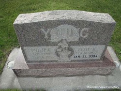
Elsie Mae Callantine Young
| Birth | : | 16 Feb 1917 Maudlow, Gallatin County, Montana, USA |
| Death | : | 23 Jan 2004 Livingston, Park County, Montana, USA |
| Burial | : | All Saints Churchyard, Eyeworth, Central Bedfordshire Unitary Authority, England |
| Coordinate | : | 52.0945940, -0.1770800 |
| Plot | : | Old B19 L7 W1/2 G1 |
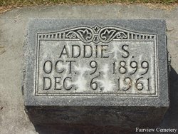
| Description | : | Obit for Elsie Young: Livingston Enterprise - Monday, January 26, 2004 Elsie Mae Young, 86, of Livingston, died at Livingston Health and Rehabilitation Center on Friday evning, January 23, 2004. Elsie was born on February 16, 1917 in Maudlow, Montana, the daughter of Claude and Addie (Shay) Callantine. She attended schools in Maudlow. In 1933 she married Marvin Crane in Livingston. They lived for a time at Chestnut, Montana before moving to Bozeman. Elsie worked for many years at Beal Park Nursery School in Bozeman. Mr. Crane died in 1956. In September of 1957 she married Philip C.... Read More |
frequently asked questions (FAQ):
-
Where is Elsie Mae Callantine Young's memorial?
Elsie Mae Callantine Young's memorial is located at: All Saints Churchyard, Eyeworth, Central Bedfordshire Unitary Authority, England.
-
When did Elsie Mae Callantine Young death?
Elsie Mae Callantine Young death on 23 Jan 2004 in Livingston, Park County, Montana, USA
-
Where are the coordinates of the Elsie Mae Callantine Young's memorial?
Latitude: 52.0945940
Longitude: -0.1770800
Family Members:
Parent
Spouse
Siblings
Children
Flowers:
Nearby Cemetories:
1. All Saints Churchyard
Eyeworth, Central Bedfordshire Unitary Authority, England
Coordinate: 52.0945940, -0.1770800
2. St Mary Magdalene Churchyard
Dunton, Central Bedfordshire Unitary Authority, England
Coordinate: 52.0825200, -0.1955600
3. Dunton Cemetery
Dunton, Central Bedfordshire Unitary Authority, England
Coordinate: 52.0820490, -0.1982770
4. St. Mary's Churchyard
Guilden Morden, South Cambridgeshire District, England
Coordinate: 52.0806930, -0.1336810
5. Guilden Morden Burial Ground
Guilden Morden, South Cambridgeshire District, England
Coordinate: 52.0832700, -0.1311000
6. All Saints Churchyard
Sutton, Central Bedfordshire Unitary Authority, England
Coordinate: 52.1126500, -0.2212200
7. Potton Baptist Church (Defunct)
Potton, Central Bedfordshire Unitary Authority, England
Coordinate: 52.1242617, -0.2096524
8. St John the Baptist Churchyard
Cockayne Hatley, Central Bedfordshire Unitary Authority, England
Coordinate: 52.1308660, -0.1663740
9. St Mary the Virgin Churchyard
Potton, Central Bedfordshire Unitary Authority, England
Coordinate: 52.1295800, -0.2066700
10. St Peter and St Paul
Steeple Morden, South Cambridgeshire District, England
Coordinate: 52.0655979, -0.1257247
11. Stratton Way Cemetery
Biggleswade, Central Bedfordshire Unitary Authority, England
Coordinate: 52.0919432, -0.2474864
12. Drove Road Cemetery
Biggleswade, Central Bedfordshire Unitary Authority, England
Coordinate: 52.0895000, -0.2527300
13. St Nicholas Churchyard
Hinxworth, North Hertfordshire District, England
Coordinate: 52.0476210, -0.1970460
14. St Michael and All Angels Churchyard
Abington Pigotts, South Cambridgeshire District, England
Coordinate: 52.0849450, -0.0976970
15. St George Churchyard
Edworth, Central Bedfordshire Unitary Authority, England
Coordinate: 52.0510350, -0.2189810
16. St. Denis Churchyard
East Hatley, South Cambridgeshire District, England
Coordinate: 52.1379956, -0.1233863
17. St Andrew Churchyard
Biggleswade, Central Bedfordshire Unitary Authority, England
Coordinate: 52.0875360, -0.2666970
18. St George Church
Hatley St George, South Cambridgeshire District, England
Coordinate: 52.1437000, -0.1348000
19. St Mary the Virgin Churchyard
Gamlingay, South Cambridgeshire District, England
Coordinate: 52.1549840, -0.1872690
20. Langford Cemetery
Langford, Central Bedfordshire Unitary Authority, England
Coordinate: 52.0640000, -0.2710830
21. St Mary Magdalene's Church
Caldecote, North Hertfordshire District, England
Coordinate: 52.0304700, -0.1989020
22. All Saints Churchyard
Wendy, South Cambridgeshire District, England
Coordinate: 52.1110400, -0.0703100
23. St Andrew Churchyard
Langford, Central Bedfordshire Unitary Authority, England
Coordinate: 52.0583270, -0.2721350
24. All Saints Churchyard
Croydon, South Cambridgeshire District, England
Coordinate: 52.1290100, -0.0796720


