
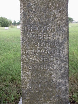
George Washington Cress
| Birth | : | 29 Jul 1818 Grayson County, Virginia, USA |
| Death | : | 16 Apr 1887 Morris County, Kansas, USA |
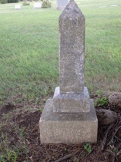
| Burial | : | Bear Creek Church Cemetery, Parsons, Decatur County, USA |
| Coordinate | : | 35.6491130, -88.1481300 |
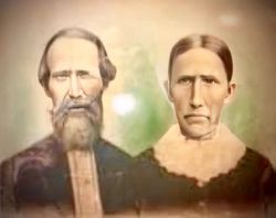
| Description | : | Son of George W. Cress and Nancy Reed. Married to Nancy Parker on 29 Jun, 1839 in Lee Co, VA. 5 children. ********************************************** The Council Grove Republican, 28 Apr 1887, Friday DIED. CRESS. -- At his home, on Clark's creek, April 16th, 1887, aged 69 years, 8 months and 13 days, was buried in Highland cemetery April 17th, 1887. Presiding Elder Mitchell preaching the funeral sermon. The subject of the above notice was born in Grason (sic) county, Virginia, July 29th, 1818. He was married to Nancy Parker in 1839, came to Kansas in 1857 and... Read More |
frequently asked questions (FAQ):
-
Where is George Washington Cress's memorial?
George Washington Cress's memorial is located at: Bear Creek Church Cemetery, Parsons, Decatur County, USA.
-
When did George Washington Cress death?
George Washington Cress death on 16 Apr 1887 in Morris County, Kansas, USA
-
Where are the coordinates of the George Washington Cress's memorial?
Latitude: 35.6491130
Longitude: -88.1481300
Family Members:
Spouse

Children

Flowers:


Nearby Cemetories:
1. Bear Creek Church Cemetery
Parsons, Decatur County, USA
Coordinate: 35.6491130, -88.1481300
2. Barnett Cemetery
Parsons, Decatur County, USA
Coordinate: 35.6377790, -88.1581500
3. Keen Cemetery
Parsons, Decatur County, USA
Coordinate: 35.6459090, -88.1715020
4. Graves Cemetery
Parsons, Decatur County, USA
Coordinate: 35.6274740, -88.1421470
5. Parsons Cemetery
Parsons, Decatur County, USA
Coordinate: 35.6472200, -88.1205000
6. Rosson Cemetery
Parsons, Decatur County, USA
Coordinate: 35.6243920, -88.1377210
7. Clay Cemetery
Parsons, Decatur County, USA
Coordinate: 35.6375510, -88.1126050
8. Myracle Family Cemetery
Parsons, Decatur County, USA
Coordinate: 35.6234610, -88.1776630
9. Mount Tabor Church Cemetery
Parsons, Decatur County, USA
Coordinate: 35.6242020, -88.1169180
10. Herndon Cemetery
Parsons, Decatur County, USA
Coordinate: 35.6181970, -88.1255280
11. Dukes Cemetery
Darden, Henderson County, USA
Coordinate: 35.6435210, -88.1928930
12. Southside Church Cemetery
Parsons, Decatur County, USA
Coordinate: 35.6282030, -88.1103900
13. Gabbard Cemetery
Parsons, Decatur County, USA
Coordinate: 35.6875340, -88.1507260
14. Stills Cemetery
Parsons, Decatur County, USA
Coordinate: 35.6848660, -88.1269820
15. McMurry Cemetery
Parsons, Decatur County, USA
Coordinate: 35.6864650, -88.1294860
16. Cross Roads Church Cemetery
Parsons, Decatur County, USA
Coordinate: 35.6814030, -88.1150360
17. Hays Cemetery
Bible Hill, Decatur County, USA
Coordinate: 35.6914070, -88.1505910
18. Hill Cemetery
Parsons, Decatur County, USA
Coordinate: 35.6914190, -88.1505980
19. Houston Cemetery
Parsons, Decatur County, USA
Coordinate: 35.6171810, -88.1125870
20. Decatur County Memorial Gardens
Parsons, Decatur County, USA
Coordinate: 35.6838580, -88.1127480
21. Iron Hill Church Cemetery
Parsons, Decatur County, USA
Coordinate: 35.6638920, -88.0932450
22. Apostolic Church of Jesus Christ Cemetery
Parsons, Decatur County, USA
Coordinate: 35.6871480, -88.1106520
23. White Cemetery
Decatur County, USA
Coordinate: 35.6068993, -88.1110992
24. Houston Cemetery
Decatur County, USA
Coordinate: 35.6268997, -88.0888977