
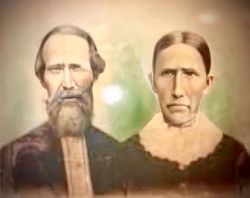
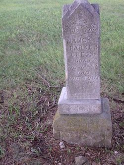
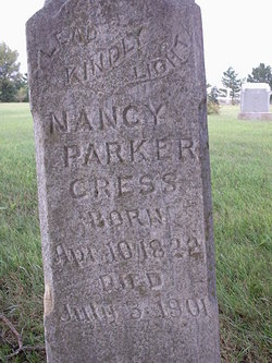
Nancy Parker Cress
| Birth | : | 10 Apr 1822 Jonesville, Lee County, Virginia, USA |
| Death | : | 3 Jul 1901 Cedar Point, Chase County, Kansas, USA |
| Burial | : | Bear Creek Church Cemetery, Parsons, Decatur County, USA |
| Coordinate | : | 35.6491130, -88.1481300 |
| Description | : | Daughter of James Parker and Matilda Fletcher. Married to George Washington Cress on 29 Jun 1839 in Lee Co, VA. 5 children. ********************************************** The Herington Times, 11 Jul 1901, Thursday Mrs. Nancy Cress, aged 79 years, died at the home of her son, J. F. Cress, at Cedar Point, Chase county, last Wednesday of dropsy. The remains were taken to Parkerville and interred in the Burton burying ground the following day. She was the grandmother of E. L. Cress of this city. ********************************************** The Weekly Guard, Council Grove, KS, 12 Jul 1901, Friday Grandmother Cress was buried in the Burton grave yard on the fourth. She... Read More |
frequently asked questions (FAQ):
-
Where is Nancy Parker Cress's memorial?
Nancy Parker Cress's memorial is located at: Bear Creek Church Cemetery, Parsons, Decatur County, USA.
-
When did Nancy Parker Cress death?
Nancy Parker Cress death on 3 Jul 1901 in Cedar Point, Chase County, Kansas, USA
-
Where are the coordinates of the Nancy Parker Cress's memorial?
Latitude: 35.6491130
Longitude: -88.1481300
Family Members:
Spouse
Children

Flowers:


Nearby Cemetories:
1. Bear Creek Church Cemetery
Parsons, Decatur County, USA
Coordinate: 35.6491130, -88.1481300
2. Barnett Cemetery
Parsons, Decatur County, USA
Coordinate: 35.6377790, -88.1581500
3. Keen Cemetery
Parsons, Decatur County, USA
Coordinate: 35.6459090, -88.1715020
4. Graves Cemetery
Parsons, Decatur County, USA
Coordinate: 35.6274740, -88.1421470
5. Parsons Cemetery
Parsons, Decatur County, USA
Coordinate: 35.6472200, -88.1205000
6. Rosson Cemetery
Parsons, Decatur County, USA
Coordinate: 35.6243920, -88.1377210
7. Clay Cemetery
Parsons, Decatur County, USA
Coordinate: 35.6375510, -88.1126050
8. Myracle Family Cemetery
Parsons, Decatur County, USA
Coordinate: 35.6234610, -88.1776630
9. Mount Tabor Church Cemetery
Parsons, Decatur County, USA
Coordinate: 35.6242020, -88.1169180
10. Herndon Cemetery
Parsons, Decatur County, USA
Coordinate: 35.6181970, -88.1255280
11. Dukes Cemetery
Darden, Henderson County, USA
Coordinate: 35.6435210, -88.1928930
12. Southside Church Cemetery
Parsons, Decatur County, USA
Coordinate: 35.6282030, -88.1103900
13. Gabbard Cemetery
Parsons, Decatur County, USA
Coordinate: 35.6875340, -88.1507260
14. Stills Cemetery
Parsons, Decatur County, USA
Coordinate: 35.6848660, -88.1269820
15. McMurry Cemetery
Parsons, Decatur County, USA
Coordinate: 35.6864650, -88.1294860
16. Cross Roads Church Cemetery
Parsons, Decatur County, USA
Coordinate: 35.6814030, -88.1150360
17. Hays Cemetery
Bible Hill, Decatur County, USA
Coordinate: 35.6914070, -88.1505910
18. Hill Cemetery
Parsons, Decatur County, USA
Coordinate: 35.6914190, -88.1505980
19. Houston Cemetery
Parsons, Decatur County, USA
Coordinate: 35.6171810, -88.1125870
20. Decatur County Memorial Gardens
Parsons, Decatur County, USA
Coordinate: 35.6838580, -88.1127480
21. Iron Hill Church Cemetery
Parsons, Decatur County, USA
Coordinate: 35.6638920, -88.0932450
22. Apostolic Church of Jesus Christ Cemetery
Parsons, Decatur County, USA
Coordinate: 35.6871480, -88.1106520
23. White Cemetery
Decatur County, USA
Coordinate: 35.6068993, -88.1110992
24. Houston Cemetery
Decatur County, USA
Coordinate: 35.6268997, -88.0888977