
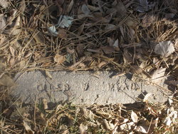
Giles Wright Mead
| Birth | : | 7 Jun 1889 Tobias, Saline County, Nebraska, USA |
| Death | : | 18 May 1934 North Platte, Lincoln County, Nebraska, USA |
| Burial | : | Forest Lawn Memorial Park, Erlanger, Kenton County, USA |
| Coordinate | : | 39.0163994, -84.5932999 |
| Description | : | Husband of Violet May Fisher Mead Buried May 21, 1934 Lot 1358 Space- 01 Giles Wright Mead June 7,1889-May 18,1934 Gales Wright Mead 45 years old, Dies Gales Wright Mead, 45 years, barber, passed away Friday evening after a brieft illness. Mr Mead operated a barber shop at 620 Grant Avenue. He had been a resident of North Platte for the past fourteen years. He was born June 7, 1889 in Tobias, Nebraska. Besides his widow, Violet Mae, six children survive. Funeral services will be held Monday, at 2:30 pm at the Baptist church with Rev. C.E.... Read More |
frequently asked questions (FAQ):
-
Where is Giles Wright Mead's memorial?
Giles Wright Mead's memorial is located at: Forest Lawn Memorial Park, Erlanger, Kenton County, USA.
-
When did Giles Wright Mead death?
Giles Wright Mead death on 18 May 1934 in North Platte, Lincoln County, Nebraska, USA
-
Where are the coordinates of the Giles Wright Mead's memorial?
Latitude: 39.0163994
Longitude: -84.5932999
Family Members:
Parent
Siblings
Children
Flowers:


Nearby Cemetories:
1. Forest Lawn Memorial Park
Erlanger, Kenton County, USA
Coordinate: 39.0163994, -84.5932999
2. Stevenson Cemetery (Defunct)
Edgewood, Kenton County, USA
Coordinate: 39.0163320, -84.5980660
3. French Cemetery
Elsmere, Kenton County, USA
Coordinate: 39.0077780, -84.5944500
4. Casey Cemetery
Edgewood, Kenton County, USA
Coordinate: 39.0254170, -84.5865000
5. Dry Creek Baptist Church Cemetery
Edgewood, Kenton County, USA
Coordinate: 39.0183330, -84.5769440
6. Mary E. Smith Cemetery
Elsmere, Kenton County, USA
Coordinate: 39.0029060, -84.5938560
7. Yager Cemetery
Erlanger, Kenton County, USA
Coordinate: 39.0027780, -84.5933330
8. Beechwood Farm Cemetery
Crestview Hills, Kenton County, USA
Coordinate: 39.0304020, -84.5756360
9. Perry Family Burying Ground
Lakeside Park, Kenton County, USA
Coordinate: 39.0333600, -84.5724130
10. Wilhoit Cemetery
Florence, Boone County, USA
Coordinate: 38.9974070, -84.6187990
11. Ashbrook-Cheek Cemetery (Defunct)
Florence, Boone County, USA
Coordinate: 39.0116670, -84.6308350
12. Jarrell Cemetery
Erlanger, Kenton County, USA
Coordinate: 38.9901000, -84.5754870
13. Saint Pius X Seminary Cemetery
Florence, Boone County, USA
Coordinate: 39.0289460, -84.6280990
14. Clutterbuck Cemetery
Florence, Boone County, USA
Coordinate: 39.0041670, -84.6297230
15. Florence Cemetery
Florence, Boone County, USA
Coordinate: 39.0001000, -84.6309800
16. Passionist Monastery Cemetery
Erlanger, Kenton County, USA
Coordinate: 39.0350600, -84.6305300
17. Walton Cemetery
Hebron, Boone County, USA
Coordinate: 39.0456700, -84.6198900
18. Cain Cemetery
Edgewood, Kenton County, USA
Coordinate: 38.9905560, -84.5611110
19. Riggs Cemetery (Defunct)
Crescent Springs, Kenton County, USA
Coordinate: 39.0494440, -84.6138890
20. Carpenter Family Cemetery
Florence, Boone County, USA
Coordinate: 38.9914700, -84.6298610
21. Senour Cemetery
Edgewood, Kenton County, USA
Coordinate: 38.9905320, -84.5563500
22. Tupman Cemetery
Villa Hills, Kenton County, USA
Coordinate: 39.0528600, -84.6153440
23. Highland Pet Cemetery
Fort Mitchell, Kenton County, USA
Coordinate: 39.0384507, -84.5483047
24. Northern Kentucky Police K-9 Memorial
Fort Mitchell, Kenton County, USA
Coordinate: 39.0387149, -84.5476438