
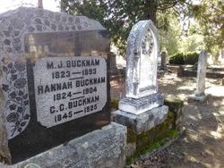

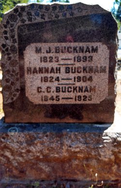

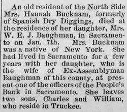
Hannah Winchell Bucknam
| Birth | : | Oct 1825 New York, USA |
| Death | : | 7 Jan 1904 Sacramento, Sacramento County, California, USA |
| Burial | : | Georgetown Pioneer Cemetery, Georgetown, El Dorado County, USA |
| Coordinate | : | 38.9068108, -120.8430862 |
| Plot | : | Sec OM, R4, P1 (Per Georgetown Divide Historical Society list, circa 1990s) |
| Description | : | See her husband's bio for family. 1900 census record states she had three children, all still living. |
frequently asked questions (FAQ):
-
Where is Hannah Winchell Bucknam's memorial?
Hannah Winchell Bucknam's memorial is located at: Georgetown Pioneer Cemetery, Georgetown, El Dorado County, USA.
-
When did Hannah Winchell Bucknam death?
Hannah Winchell Bucknam death on 7 Jan 1904 in Sacramento, Sacramento County, California, USA
-
Where are the coordinates of the Hannah Winchell Bucknam's memorial?
Latitude: 38.9068108
Longitude: -120.8430862
Family Members:
Parent

Spouse

Siblings
Children

Flowers:


Nearby Cemetories:
1. Georgetown Pioneer Cemetery
Georgetown, El Dorado County, USA
Coordinate: 38.9068108, -120.8430862
2. Georgia Slide Cemetery
Georgetown, El Dorado County, USA
Coordinate: 38.9218063, -120.8377838
3. Carmelite Monastery Cemetery
Georgetown, El Dorado County, USA
Coordinate: 38.9273300, -120.8173840
4. Greenwood Pioneer Cemetery
Greenwood, El Dorado County, USA
Coordinate: 38.8985786, -120.9099274
5. Georgetown-Renke Cemetery Annex
Georgetown, El Dorado County, USA
Coordinate: 38.8964610, -120.9116240
6. Spanish Dry Diggings Cemetery
Greenwood, El Dorado County, USA
Coordinate: 38.9431600, -120.9158000
7. Alabama Flat Cemetery
Garden Valley, El Dorado County, USA
Coordinate: 38.8413660, -120.8770510
8. Josephine Mine Cemetery
Volcanoville, El Dorado County, USA
Coordinate: 38.9798000, -120.7892170
9. Todd Valley Cemetery
Placer County, USA
Coordinate: 38.9970900, -120.8541000
10. Spring Garden Indian Cemetery
Foresthill, Placer County, USA
Coordinate: 38.9998620, -120.9049310
11. Kelsey Cemetery
Kelsey, El Dorado County, USA
Coordinate: 38.7949791, -120.8200073
12. Foresthill Community Cemetery
Foresthill, Placer County, USA
Coordinate: 39.0184500, -120.8114700
13. Saint John's Catholic Churchyard
Coloma, El Dorado County, USA
Coordinate: 38.7975311, -120.8919678
14. James Marshall Monument and Gravesite
Coloma, El Dorado County, USA
Coordinate: 38.7963104, -120.8953781
15. Pioneer Cemetery
Coloma, El Dorado County, USA
Coordinate: 38.7943192, -120.8894577
16. Uniontown Cemetery
Lotus, El Dorado County, USA
Coordinate: 38.7994003, -120.9111023
17. Saint Joseph Catholic Cemetery
Foresthill, Placer County, USA
Coordinate: 39.0240200, -120.8068800
18. Indian Creek Cemetery
Coloma, El Dorado County, USA
Coordinate: 38.7974230, -120.9104530
19. Yankee Jims Cemetery
Foresthill, Placer County, USA
Coordinate: 39.0292511, -120.8614349
20. Esoteric Fraternity Cemetery
Applegate, Placer County, USA
Coordinate: 38.9946190, -120.9687490
21. Stoney Bar Cemetery
Foresthill, Placer County, USA
Coordinate: 39.0114980, -120.7408060
22. Chili Bar Toll House Cemetery
Placerville, El Dorado County, USA
Coordinate: 38.7700530, -120.8177660
23. Dickinson Family Cemetery
Placerville, El Dorado County, USA
Coordinate: 38.7970450, -120.7269010
24. Nelsonville Cemetery
Placerville, El Dorado County, USA
Coordinate: 38.7894490, -120.7380720