
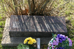

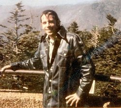
Helen Marie Nims Berry
| Birth | : | 9 May 1932 Maquoketa, Jackson County, Iowa, USA |
| Death | : | 9 Jan 1990 Davenport, Scott County, Iowa, USA |
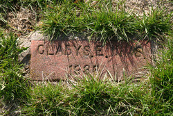
| Burial | : | Lakeside Memorial Lawn Cemetery, Folsom, Sacramento County, USA |
| Coordinate | : | 38.6715300, -121.1841000 |
| Plot | : | southwest |
| Description | : | Married to William "Wally" Berry Aug. 1952. Mother to Marcia, Duane "Pete", Mark, and Star. She was a woman of individuality of character. Her life was devoted to her family and friends. Both heart and hand responded readily to any appeal to aid, and her regret was that she could not do enough. |
frequently asked questions (FAQ):
-
Where is Helen Marie Nims Berry's memorial?
Helen Marie Nims Berry's memorial is located at: Lakeside Memorial Lawn Cemetery, Folsom, Sacramento County, USA.
-
When did Helen Marie Nims Berry death?
Helen Marie Nims Berry death on 9 Jan 1990 in Davenport, Scott County, Iowa, USA
-
Where are the coordinates of the Helen Marie Nims Berry's memorial?
Latitude: 38.6715300
Longitude: -121.1841000
Family Members:
Parent
Spouse

Siblings

Flowers:


Nearby Cemetories:
1. Lakeside Memorial Lawn Cemetery
Folsom, Sacramento County, USA
Coordinate: 38.6715300, -121.1841000
2. Young Wo Cemetery
Folsom, Sacramento County, USA
Coordinate: 38.6733400, -121.1835000
3. China Mission-Chung Wah Chinese Cemetery
Folsom, Sacramento County, USA
Coordinate: 38.6698410, -121.1851790
4. Saint John the Baptist Catholic Church Cemetery
Folsom, Sacramento County, USA
Coordinate: 38.6721900, -121.1803000
5. F.O.E. 929 Cemetery
Folsom, Sacramento County, USA
Coordinate: 38.6717010, -121.1801010
6. Folsom Prison Cemetery
Folsom, Sacramento County, USA
Coordinate: 38.6952860, -121.1636690
7. Mount Vernon Memorial Park
Fair Oaks, Sacramento County, USA
Coordinate: 38.6800003, -121.2566986
8. Mormon Island Relocation Cemetery
El Dorado Hills, El Dorado County, USA
Coordinate: 38.6986084, -121.1093521
9. Fair Oaks Cemetery
Fair Oaks, Sacramento County, USA
Coordinate: 38.6501167, -121.2792000
10. Fair Oaks United Methodist Church Memorial Garden
Fair Oaks, Sacramento County, USA
Coordinate: 38.6396300, -121.2744600
11. Sylvan Cemetery
Citrus Heights, Sacramento County, USA
Coordinate: 38.7001534, -121.2904587
12. Clarksville Cemetery
Clarksville, El Dorado County, USA
Coordinate: 38.6546707, -121.0615387
13. Kilgore Cemetery
Rancho Cordova, Sacramento County, USA
Coordinate: 38.5978012, -121.2683029
14. Railroad House Cemetery
Clarksville, El Dorado County, USA
Coordinate: 38.6575699, -121.0516129
15. Calvary Catholic Cemetery and Mausoleum
Sacramento, Sacramento County, USA
Coordinate: 38.6937180, -121.3233109
16. Boothill Cemetery
Roseville, Placer County, USA
Coordinate: 38.7598730, -121.2712130
17. Roseville Public Cemetery District
Roseville, Placer County, USA
Coordinate: 38.7606010, -121.2707977
18. Sierra Hills Memorial Park
Sacramento, Sacramento County, USA
Coordinate: 38.6843987, -121.3281021
19. Sierra Hills Pet Cemetery
Sacramento, Sacramento County, USA
Coordinate: 38.6863500, -121.3305300
20. Morrison Ranch Family Cemetery
Clarksville, El Dorado County, USA
Coordinate: 38.6552887, -121.0368500
21. Rocklin Cemetery
Rocklin, Placer County, USA
Coordinate: 38.7827670, -121.2337980
22. Shepherd of the Sierra Memorial Garden
Loomis, Placer County, USA
Coordinate: 38.7890800, -121.1944200
23. Carmichael Presbyterian Church Columbarium
Carmichael, Sacramento County, USA
Coordinate: 38.6179500, -121.3324500
24. Rust Family Gravesite
Cameron Park, El Dorado County, USA
Coordinate: 38.6980160, -121.0207130