James Beaty
| Birth | : | 1802 Preston County, West Virginia, USA |
| Death | : | 7 Aug 1878 |
| Burial | : | St. Michael & All Angels Churchyard, Penkridge, South Staffordshire Borough, England |
| Coordinate | : | 52.7245874, -2.1181258 |
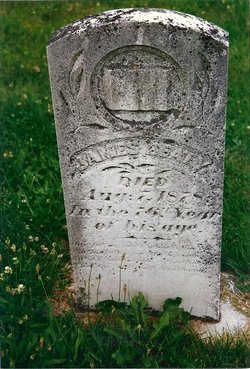
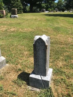
| Inscription | : | James Beaty Died Aug 7, 1878, in the 76th year of his age |
| Description | : | OBITUARY: Keota Eagle, approx Aug 10, 1878. "DIED - Another old landmark has been removed from Dutch Creek, in the person of Mr. James Beatty (sic), who died Wednesday evening and buried in the Moravian cemetery, Thursday at 4pm. Father Beatty was born in Preston Co, WV in 1802, came to Iowa and settled in D. C. (Dutch Creek) in 1856, and has resided there most of the time since, except 3 years he spent in Lafayette Twp, Keokuk Co. He raised a family of 9 children, 3 boys and 6 girls, 8 of whom are still living. He has... Read More |
frequently asked questions (FAQ):
-
Where is James Beaty's memorial?
James Beaty's memorial is located at: St. Michael & All Angels Churchyard, Penkridge, South Staffordshire Borough, England.
-
When did James Beaty death?
James Beaty death on 7 Aug 1878 in
-
Where are the coordinates of the James Beaty's memorial?
Latitude: 52.7245874
Longitude: -2.1181258
Family Members:
Parent
Spouse
Siblings
Children
Flowers:
Nearby Cemetories:
1. Christ Church
Gailey, South Staffordshire Borough, England
Coordinate: 52.6933900, -2.1308200
2. St. James Churchyard
Acton Trussell, South Staffordshire Borough, England
Coordinate: 52.7546980, -2.0943120
3. Saint John's Churchyard
Stretton, South Staffordshire Borough, England
Coordinate: 52.6999790, -2.1720920
4. All Saints Churchyard
Lapley, South Staffordshire Borough, England
Coordinate: 52.7138900, -2.1902330
5. St. Saviour Churchyard
Hatherton, South Staffordshire Borough, England
Coordinate: 52.6841730, -2.0660840
6. St Mary and All Saints
Bradley, Stafford Borough, England
Coordinate: 52.7599257, -2.1808769
7. Cannock Chase War Cemetery
Cannock, Cannock Chase District, England
Coordinate: 52.7370710, -2.0266340
8. Cannock Chase German Military Cemetery
Cannock, Cannock Chase District, England
Coordinate: 52.7370580, -2.0265050
9. Cannock Cemetery
Cannock, Cannock Chase District, England
Coordinate: 52.7008790, -2.0288950
10. St Mary and St Chad Churchyard
Brewood, South Staffordshire Borough, England
Coordinate: 52.6754850, -2.1738520
11. St. Luke's Churchyard
Cannock, Cannock Chase District, England
Coordinate: 52.6889919, -2.0287352
12. St Mary Roman Catholic Churchyard
Cannock, Cannock Chase District, England
Coordinate: 52.6867620, -2.0283360
13. St. Editha's Parish Church Graveyard
Church Eaton, Stafford Borough, England
Coordinate: 52.7560690, -2.2259540
14. St Giles Churchyard
Haughton, Stafford Borough, England
Coordinate: 52.7817750, -2.2005140
15. Our Lady of Lourdes Churchyard
Hednesford, Cannock Chase District, England
Coordinate: 52.7051311, -1.9969935
16. St. Peter's Churchyard
Hednesford, Cannock Chase District, England
Coordinate: 52.7050630, -1.9918330
17. Cheslyn Hay Cemetery
Cheslyn Hay, South Staffordshire Borough, England
Coordinate: 52.6581170, -2.0431790
18. St. Mary's Churchyard
Stafford, Stafford Borough, England
Coordinate: 52.8057000, -2.1187000
19. St Chad
Stafford, Stafford Borough, England
Coordinate: 52.8061611, -2.1165797
20. St. Mark's Churchyard
Great Wyrley, South Staffordshire Borough, England
Coordinate: 52.6664250, -2.0231955
21. Great Wyrley Cemetery
Great Wyrley, South Staffordshire Borough, England
Coordinate: 52.6642130, -2.0269380
22. Saint Johns Church
Bishops Wood, Shropshire Unitary Authority, England
Coordinate: 52.6810030, -2.2369880
23. St John Churchyard
Heath Hayes, Cannock Chase District, England
Coordinate: 52.6914160, -1.9846280
24. Stafford Crematorium and Burial Ground
Stafford, Stafford Borough, England
Coordinate: 52.8080900, -2.0747420

