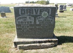
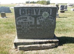
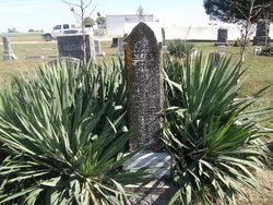
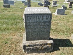
John C. Driver
| Birth | : | 24 Mar 1843 Virginia, USA |
| Death | : | 26 Sep 1912 Versailles, Morgan County, Missouri, USA |
| Burial | : | Pleasant Grove Cemetery, Pleasant Grove, Sutter County, USA |
| Coordinate | : | 38.8230000, -121.5206900 |
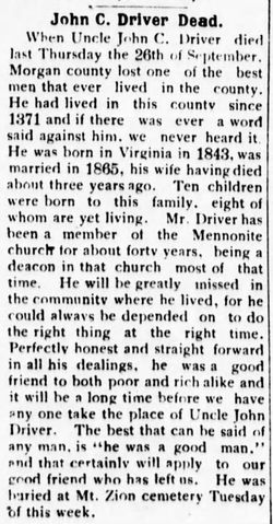
| Description | : | John C. Driver was born in the Shenandoah Valley, Va., March 24, 1843; died near Versailles, Mo., Sept. 26, 1912; aged 69 y. 6 m. 2 d. He was married to Catharine Branner in 1866. To this union were born 6 sons and 4 daughters, of which 5 sons and 3 daughters survive him. His wife died about 3 years ago. Bro. Driver was a member of the Mennonite Church for more than forty years. He served the Church in various capacities. Besides being a member of the local mission board from its organization several years ago, he served the... Read More |
frequently asked questions (FAQ):
-
Where is John C. Driver's memorial?
John C. Driver's memorial is located at: Pleasant Grove Cemetery, Pleasant Grove, Sutter County, USA.
-
When did John C. Driver death?
John C. Driver death on 26 Sep 1912 in Versailles, Morgan County, Missouri, USA
-
Where are the coordinates of the John C. Driver's memorial?
Latitude: 38.8230000
Longitude: -121.5206900
Family Members:
Parent
Spouse
Siblings
Children
Flowers:
Nearby Cemetories:
1. Pleasant Grove Cemetery
Pleasant Grove, Sutter County, USA
Coordinate: 38.8230000, -121.5206900
2. Nicolaus Cemetery
Nicolaus, Sutter County, USA
Coordinate: 38.8958015, -121.5639038
3. Fairview Cemetery
Rio Oso, Sutter County, USA
Coordinate: 38.9389000, -121.5250015
4. School House Park Cemetery
Roseville, Placer County, USA
Coordinate: 38.7893180, -121.3578670
5. Union Cemetery
Roseville, Placer County, USA
Coordinate: 38.7302600, -121.3924200
6. Knights Landing Cemetery
Knights Landing, Yolo County, USA
Coordinate: 38.7904530, -121.7284190
7. Santa Clara Memorial Park
Lincoln, Placer County, USA
Coordinate: 38.8894710, -121.3260560
8. Lincoln Cemetery
Lincoln, Placer County, USA
Coordinate: 38.8864310, -121.3020500
9. Sunset Lawn Chapel of the Chimes Memorial Park
Sacramento, Sacramento County, USA
Coordinate: 38.6514816, -121.4384842
10. Wheatland Cemetery
Wheatland, Yuba County, USA
Coordinate: 39.0083008, -121.4360962
11. Sheridan Cemetery
Sheridan, Placer County, USA
Coordinate: 38.9741000, -121.3585300
12. Calvary Catholic Cemetery and Mausoleum
Sacramento, Sacramento County, USA
Coordinate: 38.6937180, -121.3233109
13. Sierra Hills Pet Cemetery
Sacramento, Sacramento County, USA
Coordinate: 38.6863500, -121.3305300
14. Sierra Hills Memorial Park
Sacramento, Sacramento County, USA
Coordinate: 38.6843987, -121.3281021
15. Boothill Cemetery
Roseville, Placer County, USA
Coordinate: 38.7598730, -121.2712130
16. Roseville Public Cemetery District
Roseville, Placer County, USA
Coordinate: 38.7606010, -121.2707977
17. Manzanita Cemetery
Lincoln, Placer County, USA
Coordinate: 38.9444008, -121.3032990
18. Whitney Family Mausoleum
Rocklin, Placer County, USA
Coordinate: 38.8256500, -121.2477000
19. Sylvan Cemetery
Citrus Heights, Sacramento County, USA
Coordinate: 38.7001534, -121.2904587
20. Rocklin Cemetery
Rocklin, Placer County, USA
Coordinate: 38.7827670, -121.2337980
21. Marys Cemetery
Yolo, Yolo County, USA
Coordinate: 38.7635994, -121.8032990
22. Morgan Oaks Eternal Preserve
Lincoln, Placer County, USA
Coordinate: 38.9629050, -121.2860530
23. Holy Ascension Russian Orthodox Cemetery
Sacramento, Sacramento County, USA
Coordinate: 38.5846212, -121.4936736
24. Cacheville Cemetery
Yolo, Yolo County, USA
Coordinate: 38.7378300, -121.8090200

