
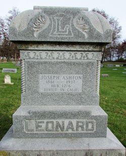
| Birth | : | 14 Nov 1862 Clear Creek Township, Jasper County, Iowa, USA |
| Death | : | 20 Jan 1937 Sacramento, Sacramento County, California, USA |
| Burial | : | Sylvan Cemetery, Citrus Heights, Sacramento County, USA |
| Coordinate | : | 38.7001534, -121.2904587 |
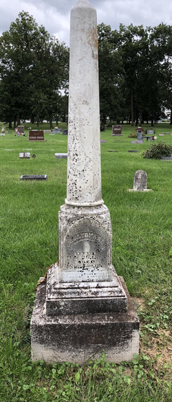
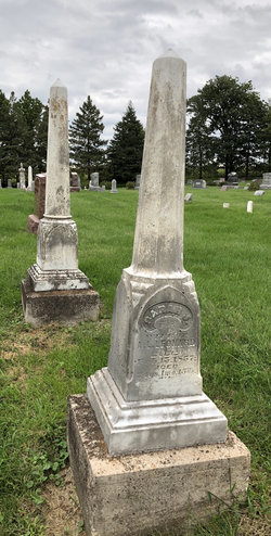
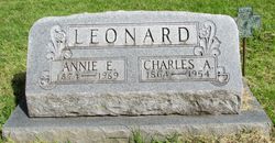
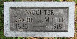
| Description | : | Joseph Aston Leonard also has a second Find-A-Grave memorial, 193920826, located in Ashton Cemetery, Jasper County, Iowa. This is where another Leonard family burial plot is located. There his tombstone stands among those of his parents, Abiram Longwell Leonard and Sarah Ashton Leonard, his wife, Grace Enola Cooper Leonard and both daughters; Carolyn Oral Leonard Miller, and Mary Leora Leonard. Joseph Ashton Leonard was the son of Abiram Longwell Leonard and Sarah Ashton, born in Clear Creek Township, Jasper County, Iowa, on 14 November 1862. He was the first of four sons (Joseph Ashton, Charles Avery, Harvy and... Read More |
frequently asked questions (FAQ):
-
Where is Joseph Ashton Leonard's memorial?
Joseph Ashton Leonard's memorial is located at: Sylvan Cemetery, Citrus Heights, Sacramento County, USA.
-
When did Joseph Ashton Leonard death?
Joseph Ashton Leonard death on 20 Jan 1937 in Sacramento, Sacramento County, California, USA
-
Where are the coordinates of the Joseph Ashton Leonard's memorial?
Latitude: 38.7001534
Longitude: -121.2904587
Family Members:
Parent
Siblings

Children
Flowers:


Nearby Cemetories:
1. Sylvan Cemetery
Citrus Heights, Sacramento County, USA
Coordinate: 38.7001534, -121.2904587
2. Calvary Catholic Cemetery and Mausoleum
Sacramento, Sacramento County, USA
Coordinate: 38.6937180, -121.3233109
3. Mount Vernon Memorial Park
Fair Oaks, Sacramento County, USA
Coordinate: 38.6800003, -121.2566986
4. Sierra Hills Memorial Park
Sacramento, Sacramento County, USA
Coordinate: 38.6843987, -121.3281021
5. Sierra Hills Pet Cemetery
Sacramento, Sacramento County, USA
Coordinate: 38.6863500, -121.3305300
6. Fair Oaks Cemetery
Fair Oaks, Sacramento County, USA
Coordinate: 38.6501167, -121.2792000
7. Boothill Cemetery
Roseville, Placer County, USA
Coordinate: 38.7598730, -121.2712130
8. Fair Oaks United Methodist Church Memorial Garden
Fair Oaks, Sacramento County, USA
Coordinate: 38.6396300, -121.2744600
9. Roseville Public Cemetery District
Roseville, Placer County, USA
Coordinate: 38.7606010, -121.2707977
10. Union Cemetery
Roseville, Placer County, USA
Coordinate: 38.7302600, -121.3924200
11. China Mission-Chung Wah Chinese Cemetery
Folsom, Sacramento County, USA
Coordinate: 38.6698410, -121.1851790
12. Young Wo Cemetery
Folsom, Sacramento County, USA
Coordinate: 38.6733400, -121.1835000
13. Lakeside Memorial Lawn Cemetery
Folsom, Sacramento County, USA
Coordinate: 38.6715300, -121.1841000
14. Carmichael Presbyterian Church Columbarium
Carmichael, Sacramento County, USA
Coordinate: 38.6179500, -121.3324500
15. Saint John the Baptist Catholic Church Cemetery
Folsom, Sacramento County, USA
Coordinate: 38.6721900, -121.1803000
16. F.O.E. 929 Cemetery
Folsom, Sacramento County, USA
Coordinate: 38.6717010, -121.1801010
17. Rocklin Cemetery
Rocklin, Placer County, USA
Coordinate: 38.7827670, -121.2337980
18. Folsom Prison Cemetery
Folsom, Sacramento County, USA
Coordinate: 38.6952860, -121.1636690
19. School House Park Cemetery
Roseville, Placer County, USA
Coordinate: 38.7893180, -121.3578670
20. Kilgore Cemetery
Rancho Cordova, Sacramento County, USA
Coordinate: 38.5978012, -121.2683029
21. Saint Michaels Episcopal Church Columbarium
Carmichael, Sacramento County, USA
Coordinate: 38.6042800, -121.3547200
22. Saint Marks Methodist Church Memorial Tree
Sacramento, Sacramento County, USA
Coordinate: 38.6076500, -121.3750680
23. Shepherd of the Sierra Memorial Garden
Loomis, Placer County, USA
Coordinate: 38.7890800, -121.1944200
24. Sunset Lawn Chapel of the Chimes Memorial Park
Sacramento, Sacramento County, USA
Coordinate: 38.6514816, -121.4384842