
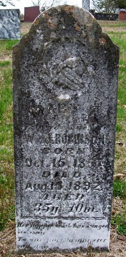
Mary Ann Stubblefield Robinson
| Birth | : | 15 Oct 1857 Randolph County, Arkansas, USA |
| Death | : | 15 Aug 1892 Myrtle, Oregon County, Missouri, USA |
| Burial | : | Plain Cemetery, Ashfield, Franklin County, USA |
| Coordinate | : | 42.5292015, -72.7889023 |
| Description | : | MARY ANN STUBBLEFIELD was born 15 Oct 1857 in Randolph County, Arkansas, to JOSEPH and MARTHA ELIZABETH HALL STUBBLEFIELD. Mary married GEORGE WASHINGTON GOINS 13 Jan 1878 in Oregon County, Missouri, son of JOHN GOINS and MARTHA GRAHAM. He was born 10 Sep 1851 in Tennessee. Children from this union: 1. MARTHA GOINS born 03 Dec 1878 in Oregon County, Missouri. Martha's first marriage was to WILLIAM F BREWER on 30 Jul 1896 in Myrtle, Oregon County, Missouri. After the death of William Brewer, Martha married her second husband ALEXANDER JEFFERSON HALL in 1904 in Oregon County, Missouri. Martha... Read More |
frequently asked questions (FAQ):
-
Where is Mary Ann Stubblefield Robinson's memorial?
Mary Ann Stubblefield Robinson's memorial is located at: Plain Cemetery, Ashfield, Franklin County, USA.
-
When did Mary Ann Stubblefield Robinson death?
Mary Ann Stubblefield Robinson death on 15 Aug 1892 in Myrtle, Oregon County, Missouri, USA
-
Where are the coordinates of the Mary Ann Stubblefield Robinson's memorial?
Latitude: 42.5292015
Longitude: -72.7889023
Family Members:
Parent
Spouse
Siblings

Children
Flowers:

Left by Anonymous on 15 Dec 2008
Left by Anonymous on 30 Dec 2008

Left by Anonymous on 24 Apr 2009

Left by Anonymous on 01 Nov 2009
Left by Anonymous on 16 Dec 2009

Left by Anonymous on 25 May 2010

Left by Anonymous on 08 Oct 2010

Mary Ann is my 2nd cousin 3x removed
Left by Anonymous on 10 Sep 2011

Left by Anonymous on 10 Sep 2011

Left by Anonymous on 06 Mar 2012

Left by Anonymous on 21 Oct 2015

Left by Anonymous on 09 Nov 2015

Left by Anonymous on 29 Sep 2021


Nearby Cemetories:
1. Plain Cemetery
Ashfield, Franklin County, USA
Coordinate: 42.5292015, -72.7889023
2. Saint John's Church
Ashfield, Franklin County, USA
Coordinate: 42.5258600, -72.7894260
3. Hill Cemetery
Ashfield, Franklin County, USA
Coordinate: 42.5208015, -72.7992020
4. Beldingville Cemetery
Ashfield, Franklin County, USA
Coordinate: 42.5365562, -72.7638016
5. South Ashfield Cemetery
Ashfield, Franklin County, USA
Coordinate: 42.5077209, -72.7730026
6. Baptist Corner Cemetery
Ashfield, Franklin County, USA
Coordinate: 42.5540771, -72.7639313
7. Northwest Cemetery
Ashfield, Franklin County, USA
Coordinate: 42.5587500, -72.8250500
8. Spruce Corner Cemetery
Ashfield, Franklin County, USA
Coordinate: 42.5026817, -72.8481293
9. Briar Hill Cemetery
Ashfield, Franklin County, USA
Coordinate: 42.4742600, -72.7798300
10. Old Cemetery #01
Buckland, Franklin County, USA
Coordinate: 42.5918580, -72.7906890
11. Center Cemetery #03
Buckland, Franklin County, USA
Coordinate: 42.5926950, -72.7898960
12. North Shirkshire Cemetery
Conway, Franklin County, USA
Coordinate: 42.5689011, -72.7210999
13. Upper City Cemetery
Buckland, Franklin County, USA
Coordinate: 42.5832640, -72.8355360
14. Trow Cemetery #04
Buckland, Franklin County, USA
Coordinate: 42.5932800, -72.7915000
15. Taylor Cemetery #02
Buckland, Franklin County, USA
Coordinate: 42.5932808, -72.7915039
16. East Street Cemetery
Plainfield, Hampshire County, USA
Coordinate: 42.5136600, -72.8780700
17. Maynard Cemetery
Conway, Franklin County, USA
Coordinate: 42.4836630, -72.7195800
18. Old East Buckland Cemetery
Buckland, Franklin County, USA
Coordinate: 42.5969400, -72.7677900
19. Howland Cemetery
Conway, Franklin County, USA
Coordinate: 42.5127983, -72.6967010
20. East Buckland Cemetery
Buckland, Franklin County, USA
Coordinate: 42.5962500, -72.7610600
21. Southwest Cemetery
Conway, Franklin County, USA
Coordinate: 42.4660280, -72.7458610
22. Pine Grove Cemetery
Conway, Franklin County, USA
Coordinate: 42.5222015, -72.6908035
23. East Hawley Cemetery
Hawley, Franklin County, USA
Coordinate: 42.5621071, -72.8768005
24. South Centre Cemetery
Conway, Franklin County, USA
Coordinate: 42.5015940, -72.6973490