
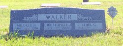
Mildred Nellie Walsh Walker
| Birth | : | 21 Sep 1916 Jackson County, Kansas, USA |
| Death | : | 19 Oct 1956 Tonganoxie, Leavenworth County, Kansas, USA |
| Burial | : | Saint John's Catholic Cemetery, Delphos, Allen County, USA |
| Coordinate | : | 40.8423620, -84.3319580 |
| Description | : | MAYETTA WOMAN AND BABY CRASH VICTIMS Mrs. Christopher Walker, 41, Mayetta, and her infant son, Christopher, jr., were killed Friday afternoon at Tonganoxie where the car in which she and her husband and two other children were riding collided with a truck. The accident took place at the intersection of K-16 and US 24-40 at the edge of Tonganoxie. The Walker car was hit by a semi-trailer truck as it pulled into the intersection. Mr. Walker and two other children, Patricia and Kathleen, were treated at the... Read More |
frequently asked questions (FAQ):
-
Where is Mildred Nellie Walsh Walker's memorial?
Mildred Nellie Walsh Walker's memorial is located at: Saint John's Catholic Cemetery, Delphos, Allen County, USA.
-
When did Mildred Nellie Walsh Walker death?
Mildred Nellie Walsh Walker death on 19 Oct 1956 in Tonganoxie, Leavenworth County, Kansas, USA
-
Where are the coordinates of the Mildred Nellie Walsh Walker's memorial?
Latitude: 40.8423620
Longitude: -84.3319580
Family Members:
Parent

Spouse

Siblings
Children
Flowers:


Nearby Cemetories:
1. Westside Cemetery
Delphos, Van Wert County, USA
Coordinate: 40.8452988, -84.3507996
2. Hartshorn Cemetery
Allen County, USA
Coordinate: 40.8424988, -84.2908020
3. New Saint John's Catholic Cemetery
Delphos, Allen County, USA
Coordinate: 40.8451390, -84.2889380
4. Walnut Grove Cemetery
Delphos, Allen County, USA
Coordinate: 40.8300018, -84.2906036
5. King Cemetery
Marion Township, Allen County, USA
Coordinate: 40.8060989, -84.2869034
6. Saint John the Baptist Catholic Cemetery
Landeck, Allen County, USA
Coordinate: 40.7999992, -84.3874969
7. Mount Calvary Cemetery
Fort Jennings, Putnam County, USA
Coordinate: 40.8986015, -84.3035965
8. Raabe Cemetery
Fort Jennings, Putnam County, USA
Coordinate: 40.8993988, -84.2789001
9. Saint Joseph Cemetery
Fort Jennings, Putnam County, USA
Coordinate: 40.9056015, -84.2928009
10. Pike Cemetery
Elida, Allen County, USA
Coordinate: 40.7947006, -84.2585983
11. King Cemetery
Middle Point, Van Wert County, USA
Coordinate: 40.8664017, -84.4377975
12. Saint Marys Cemetery
Ottoville, Putnam County, USA
Coordinate: 40.9261017, -84.3399963
13. Hammons Cemetery
Ottoville, Putnam County, USA
Coordinate: 40.9223370, -84.3701410
14. Horeb Cemetery
Venedocia, Van Wert County, USA
Coordinate: 40.8005981, -84.4341965
15. West Union Cemetery
Spencerville, Allen County, USA
Coordinate: 40.7574997, -84.3641968
16. Carmen Cemetery
Gomer, Allen County, USA
Coordinate: 40.8531380, -84.2118660
17. Doner Cemetery
Elida, Allen County, USA
Coordinate: 40.7951330, -84.2277470
18. Sharon Mennonite Cemetery
Elida, Allen County, USA
Coordinate: 40.7828080, -84.2332721
19. Keirns Cemetery
Sugar Creek Township, Putnam County, USA
Coordinate: 40.8875008, -84.2181015
20. Hadding Cemetery
Gomer, Allen County, USA
Coordinate: 40.8319016, -84.2035980
21. Hartford Cemetery
Spencerville, Allen County, USA
Coordinate: 40.7386017, -84.3158035
22. Old Hartford Cemetery
Allen County, USA
Coordinate: 40.7371788, -84.3140564
23. Ridge Cemetery
Middle Point, Van Wert County, USA
Coordinate: 40.8781013, -84.4692001
24. Lutheran Cemetery
Elida, Allen County, USA
Coordinate: 40.7877998, -84.2050018