


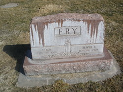
Oliver Franklin Fry
| Birth | : | 12 Nov 1871 Falls City, Richardson County, Nebraska, USA |
| Death | : | 4 Sep 1950 Hershey, Lincoln County, Nebraska, USA |
| Burial | : | St. Edmund and St. George Churchyard, Hethe, Cherwell District, England |
| Coordinate | : | 51.9604830, -1.1384690 |
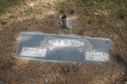
| Description | : | Buried Sept 7,1950 Lot 281 Section E Space- 01 |
frequently asked questions (FAQ):
-
Where is Oliver Franklin Fry's memorial?
Oliver Franklin Fry's memorial is located at: St. Edmund and St. George Churchyard, Hethe, Cherwell District, England.
-
When did Oliver Franklin Fry death?
Oliver Franklin Fry death on 4 Sep 1950 in Hershey, Lincoln County, Nebraska, USA
-
Where are the coordinates of the Oliver Franklin Fry's memorial?
Latitude: 51.9604830
Longitude: -1.1384690
Family Members:
Parent

Spouse
Siblings
Children
Flowers:


Nearby Cemetories:
1. St. Edmund and St. George Churchyard
Hethe, Cherwell District, England
Coordinate: 51.9604830, -1.1384690
2. Holy Trinity Churchyard
Hethe, Cherwell District, England
Coordinate: 51.9615600, -1.1452100
3. St Michaels and All Angels Churchyard
Fringford, Cherwell District, England
Coordinate: 51.9573680, -1.1189880
4. St Mary the Virgin Churchyard
Hardwick, Cherwell District, England
Coordinate: 51.9616750, -1.1615570
5. St. Mary's Churchyard
Cottisford, Cherwell District, England
Coordinate: 51.9749070, -1.1464410
6. St Peters Churchyard
Stoke Lyne, Cherwell District, England
Coordinate: 51.9505340, -1.1771680
7. St Michael & All Angels Churchyard
Newton Purcell, Cherwell District, England
Coordinate: 51.9723110, -1.0915630
8. SS Mary & Edburga Churchyard
Stratton Audley, Cherwell District, England
Coordinate: 51.9294810, -1.1164160
9. St Laurence Churchyard
Caversfield, Cherwell District, England
Coordinate: 51.9223030, -1.1571690
10. Ss Mary and Nicholas Churchyard
Chetwode, Aylesbury Vale District, England
Coordinate: 51.9630520, -1.0694610
11. Mixbury All Saints Churchyard
Mixbury, Cherwell District, England
Coordinate: 52.0010100, -1.1131800
12. St James Churchyard
Barton Harthshorn, Aylesbury Vale District, England
Coordinate: 51.9730300, -1.0686650
13. St Peter's Churchyard
Bucknell, Cherwell District, England
Coordinate: 51.9263400, -1.1861700
14. Holy Trinity
Godington, Cherwell District, England
Coordinate: 51.9452700, -1.0667470
15. St. Mary's Churchyard
Ardley, Cherwell District, England
Coordinate: 51.9422140, -1.2122580
16. Fewcott All Saints Churchyard
Albury, South Oxfordshire District, England
Coordinate: 51.9477100, -1.2170700
17. St. Michael and All Angels
Finmere, Cherwell District, England
Coordinate: 51.9931740, -1.0740240
18. All Saints Churchyard
Croughton, South Northamptonshire Borough, England
Coordinate: 51.9977370, -1.2065760
19. Croughton Cemetery
Croughton, South Northamptonshire Borough, England
Coordinate: 52.0014880, -1.2031960
20. St. John the Baptist Churchyard
Preston Bissett, Aylesbury Vale District, England
Coordinate: 51.9637380, -1.0440980
21. St Marys Churchyard
Launton, Cherwell District, England
Coordinate: 51.9006740, -1.1230300
22. Bicester Priory
Bicester, Cherwell District, England
Coordinate: 51.9000000, -1.1500000
23. St. Augustine's Churchyard
Westbury, Aylesbury Vale District, England
Coordinate: 52.0154200, -1.0941150
24. Fritwell Parish Council Cemetery
Fritwell, Cherwell District, England
Coordinate: 51.9599490, -1.2380650