
| Birth | : | 22 Oct 1876 Russia |
| Death | : | 29 Jan 1941 Hays, Ellis County, Kansas, USA |
| Burial | : | Bourne Cemetery, Bourne, South Kesteven District, England |
| Coordinate | : | 52.7607264, -0.3714663 |
| Plot | : | Sec 10, Lot 59-W-C |
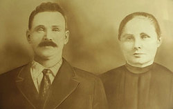
| Description | : | Peter A. Boos, 64, 1714 East Crane, died unexpectedly Wednesday night while visiting his daughter, Mrs. John Boos in Hays, Kan. He was born in Russia and came to the United States and to Ellis, Kan. in 1909. He later moved to Ness City and Topeka in 1929. He is survived by three sons, Jacob, Leo and Frank Boos, all of Topeka; six daughters, Mrs. Anna Stadler, Mrs. Rose Stattelman and Mrs. Wallburga Schwerdt, all of Topeka, Margaret and Adelaide Boos, both of the home; five brothres, Clement Boos, Topeka, Conrad Boos, Ness City, Kan., John Boos, Longmont, Colo., Alex... Read More |
frequently asked questions (FAQ):
-
Where is Peter Anton Boos's memorial?
Peter Anton Boos's memorial is located at: Bourne Cemetery, Bourne, South Kesteven District, England.
-
When did Peter Anton Boos death?
Peter Anton Boos death on 29 Jan 1941 in Hays, Ellis County, Kansas, USA
-
Where are the coordinates of the Peter Anton Boos's memorial?
Latitude: 52.7607264
Longitude: -0.3714663
Family Members:
Parent

Spouse
Siblings
Children
Flowers:


Nearby Cemetories:
1. Bourne Cemetery
Bourne, South Kesteven District, England
Coordinate: 52.7607264, -0.3714663
2. Bourne Abbey
Bourne, South Kesteven District, England
Coordinate: 52.7661320, -0.3758389
3. St Firmin Churchyard
Thurlby, South Kesteven District, England
Coordinate: 52.7375960, -0.3646650
4. St Michael Churchyard
Edenham, South Kesteven District, England
Coordinate: 52.7836110, -0.4266560
5. St John the Baptist Churchyard
Morton, South Kesteven District, England
Coordinate: 52.8025100, -0.3724200
6. Baston Cemetery
Baston, South Kesteven District, England
Coordinate: 52.7149917, -0.3531338
7. St John the Baptist Churchyard
Baston, South Kesteven District, England
Coordinate: 52.7149530, -0.3530650
8. St. Andrews Churchyard
Witham on the Hill, South Kesteven District, England
Coordinate: 52.7364500, -0.4420300
9. St Faith Churchyard
Wilsthorpe, South Kesteven District, England
Coordinate: 52.7095208, -0.3848166
10. St Andrew's Churchyard
Haconby, South Kesteven District, England
Coordinate: 52.8135400, -0.3594300
11. St Michael and All Angels Churchyard
Langtoft, South Kesteven District, England
Coordinate: 52.6990300, -0.3389800
12. Saint Stephen
Carlby, South Kesteven District, England
Coordinate: 52.7125650, -0.4475800
13. St Stephen Churchyard
Careby, South Kesteven District, England
Coordinate: 52.7363500, -0.4823700
14. St Mary Magdalene Churchyard
Essendine, Rutland Unitary Authority, England
Coordinate: 52.7026000, -0.4489000
15. St Andrew's Churchyard
Rippingale, South Kesteven District, England
Coordinate: 52.8366700, -0.3718000
16. St Martin Churchyard
Barholm, South Kesteven District, England
Coordinate: 52.6855000, -0.3887600
17. St Peter Churchyard
Creeton, South Kesteven District, England
Coordinate: 52.7669500, -0.4977300
18. St Mary Churchyard
Swinstead, South Kesteven District, England
Coordinate: 52.7900380, -0.4909380
19. St Medard and St Gildard Churchyard
Little Bytham, South Kesteven District, England
Coordinate: 52.6786110, -0.3200000
20. St Wilfrid
Holywell, South Kesteven District, England
Coordinate: 52.7329915, -0.5149881
21. St John the Evangelist Churchyard
Ryhall, Rutland Unitary Authority, England
Coordinate: 52.6852000, -0.4685000
22. Ryhall Churchyard Extension
Ryhall, Rutland Unitary Authority, England
Coordinate: 52.6849000, -0.4678700
23. St. Andrew's Churchyard
West Deeping, South Kesteven District, England
Coordinate: 52.6640285, -0.3614634
24. Aslackby Cemetery
Aslackby, South Kesteven District, England
Coordinate: 52.8597838, -0.3855002