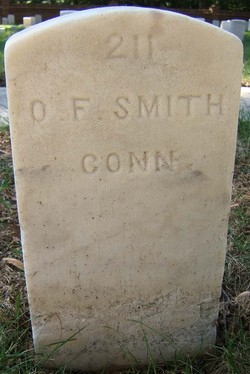
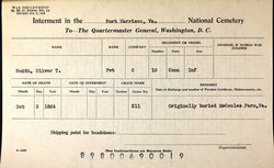
Pvt Oliver T. Smith
| Birth | : | 1840 North Haven, New Haven County, Connecticut, USA |
| Death | : | 13 Oct 1864 Henrico County, Virginia, USA |
| Burial | : | St Lawrence Churchyard, Weston Patrick, Basingstoke and Deane Borough, England |
| Coordinate | : | 51.2170740, -1.0121040 |
| Plot | : | Section B, Grave 211 |
| Description | : | This is the grave marker for SMITH, Oliver T. PVT Company C, 10TH Connecticut Infantry Died: Oct 13, 1864 see Ancestry.com. U.S. National Cemetery Interment Control Forms, 1928-1962 [database on-line]. Provo, UT, USA: Ancestry.com Operations, Inc., 2012. Original data: Interment Control Forms, 1928–1962. Interment Control Forms, A1 2110-B. Records of the Office of the Quartermaster General, 1774–1985, Record Group 92. The National Archives at College Park, College Park, Maryland. US National Cemetery Interment Control Forms, Fort Harrison National Cemetery, Oliver T. Smith. Also, Ancestry.com. U.S., Burial Registers, Military Posts and National Cemeteries, 1862-1960 [database... Read More |
frequently asked questions (FAQ):
-
Where is Pvt Oliver T. Smith's memorial?
Pvt Oliver T. Smith's memorial is located at: St Lawrence Churchyard, Weston Patrick, Basingstoke and Deane Borough, England.
-
When did Pvt Oliver T. Smith death?
Pvt Oliver T. Smith death on 13 Oct 1864 in Henrico County, Virginia, USA
-
Where are the coordinates of the Pvt Oliver T. Smith's memorial?
Latitude: 51.2170740
Longitude: -1.0121040
Family Members:
Parent
Spouse
Siblings
Flowers:
Nearby Cemetories:
1. St Lawrence Churchyard
Weston Patrick, Basingstoke and Deane Borough, England
Coordinate: 51.2170740, -1.0121040
2. St. Mary's Churchyard
Upton Grey, Basingstoke and Deane Borough, England
Coordinate: 51.2307800, -1.0025200
3. All Saints Churchyard
Tunworth, Basingstoke and Deane Borough, England
Coordinate: 51.2312600, -1.0367400
4. St Mary Churchyard
Herriard, Basingstoke and Deane Borough, England
Coordinate: 51.2093000, -1.0515700
5. St Andrew Churchyard
South Warnborough, Hart District, England
Coordinate: 51.2198000, -0.9684700
6. St Mary Churchyard
Mapledurwell, Basingstoke and Deane Borough, England
Coordinate: 51.2538100, -1.0161300
7. Long Sutton Cemetery
Long Sutton, Hart District, England
Coordinate: 51.2193610, -0.9465190
8. St Mary Churchyard
Lasham, East Hampshire District, England
Coordinate: 51.1778500, -1.0346000
9. All Saints Churchyard
Long Sutton, Hart District, England
Coordinate: 51.2207300, -0.9432800
10. St. Mary's Churchyard
Greywell, Hart District, England
Coordinate: 51.2536700, -0.9719700
11. Froyle Cemetery
Froyle, East Hampshire District, England
Coordinate: 51.1941910, -0.9479140
12. St Stephen Churchyard
Up Nately, Basingstoke and Deane Borough, England
Coordinate: 51.2627500, -0.9971500
13. St Peter and St Paul Churchyard
Shalden, East Hampshire District, England
Coordinate: 51.1703300, -1.0097400
14. St Martin Churchyard
Ellisfield, Basingstoke and Deane Borough, England
Coordinate: 51.2084970, -1.0868310
15. St. Swithun Churchyard
Nately Scures, Basingstoke and Deane Borough, England
Coordinate: 51.2719600, -1.0022200
16. St. Leonard's Churchyard
Cliddesden, Basingstoke and Deane Borough, England
Coordinate: 51.2373200, -1.0948700
17. All Saints Churchyard
Odiham, Hart District, England
Coordinate: 51.2529200, -0.9407000
18. St Mary Churchyard
Old Basing, Basingstoke and Deane Borough, England
Coordinate: 51.2715280, -1.0467700
19. Odiham Cemetery
Odiham, Hart District, England
Coordinate: 51.2521010, -0.9360700
20. Old Basing Cemetery
Old Basing, Basingstoke and Deane Borough, England
Coordinate: 51.2736710, -1.0397679
21. St. Andrew's Churchyard
Farleigh Wallop, Basingstoke and Deane Borough, England
Coordinate: 51.2234400, -1.1064200
22. Holy Rood Churchyard
Holybourne, East Hampshire District, England
Coordinate: 51.1657120, -0.9535570
23. St Mary Churchyard
Bentworth, East Hampshire District, England
Coordinate: 51.1579900, -1.0499460
24. St Mary Churchyard
Bentworth, East Hampshire District, England
Coordinate: 51.1579100, -1.0500600


