

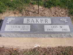
Viola Olive Thompson Baker
| Birth | : | 20 Apr 1906 Ottawa, Franklin County, Kansas, USA |
| Death | : | 22 Feb 2004 Dunlap, Harrison County, Iowa, USA |
| Burial | : | St Peter's Churchyard, St Albans, St Albans District, England |
| Coordinate | : | 51.7555400, -0.3350270 |
| Description | : | Married Leo William Baker |
frequently asked questions (FAQ):
-
Where is Viola Olive Thompson Baker's memorial?
Viola Olive Thompson Baker's memorial is located at: St Peter's Churchyard, St Albans, St Albans District, England.
-
When did Viola Olive Thompson Baker death?
Viola Olive Thompson Baker death on 22 Feb 2004 in Dunlap, Harrison County, Iowa, USA
-
Where are the coordinates of the Viola Olive Thompson Baker's memorial?
Latitude: 51.7555400
Longitude: -0.3350270
Family Members:
Parent

Spouse
Siblings
Children
Flowers:


Nearby Cemetories:
1. St Peter's Churchyard
St Albans, St Albans District, England
Coordinate: 51.7555400, -0.3350270
2. Dagnall Lane Baptist Chapel
St Albans, St Albans District, England
Coordinate: 51.7526990, -0.3405156
3. Spicer Street Chapel Burial Ground
St Albans, St Albans District, England
Coordinate: 51.7523288, -0.3423231
4. Saint Alban's Cathedral
St Albans, St Albans District, England
Coordinate: 51.7504425, -0.3423680
5. Romeland Hill Garden of Rest
St Albans, St Albans District, England
Coordinate: 51.7514540, -0.3438830
6. Hatfield Road Cemetery
St Albans, St Albans District, England
Coordinate: 51.7523003, -0.3192620
7. St Michael’s Churchyard
St Albans, St Albans District, England
Coordinate: 51.7529540, -0.3560640
8. St. Stephen's Churchyard
St Albans, St Albans District, England
Coordinate: 51.7417450, -0.3483370
9. Childwickbury Manor
Childwickbury, St Albans District, England
Coordinate: 51.7809460, -0.3499100
10. London Road Cemetery
St Albans, St Albans District, England
Coordinate: 51.7333610, -0.3066110
11. St Mary Churchyard
Childwickbury, St Albans District, England
Coordinate: 51.7836980, -0.3473020
12. St Leonard Churchyard & Extension
Sandridge, St Albans District, England
Coordinate: 51.7813690, -0.3036580
13. Frogmore Holy Trinity Burial Ground
St Albans District, England
Coordinate: 51.7197598, -0.3365342
14. Holy Trinity Churchyard
St Albans, St Albans District, England
Coordinate: 51.7170354, -0.3334244
15. Sir David Yule Mausoleum
St Albans, St Albans District, England
Coordinate: 51.7024660, -0.3505190
16. St. Mary's Churchyard
Redbourn, St Albans District, England
Coordinate: 51.7916200, -0.4066100
17. Woodwells Cemetery
Hemel Hempstead, Dacorum Borough, England
Coordinate: 51.7576500, -0.4280300
18. Holy Trinity Churchyard
Leverstock Green, Dacorum Borough, England
Coordinate: 51.7466800, -0.4295770
19. Saint Bololph's Churchyard
Shenley, Hertsmere Borough, England
Coordinate: 51.7030296, -0.2890460
20. Wheathampstead United Churchyard
Wheathampstead, St Albans District, England
Coordinate: 51.8108170, -0.2972210
21. St. Helen's Churchyard
Wheathampstead, St Albans District, England
Coordinate: 51.8124510, -0.2946400
22. St Nicholas Churchyard
Harpenden, St Albans District, England
Coordinate: 51.8169470, -0.3583300
23. West Herts Crematorium
Watford, Watford Borough, England
Coordinate: 51.7004195, -0.3847509
24. East Lane Cemetery
Leavesden, Three Rivers District, England
Coordinate: 51.7084796, -0.4036263