
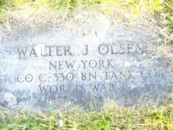
Walter J. Olsen
| Birth | : | 6 Sep 1889 Brooklyn, Kings County (Brooklyn), New York, USA |
| Death | : | 2 Oct 1954 Martinsburg, Berkeley County, West Virginia, USA |
| Burial | : | Monk Fryston Cemetery, Monk Fryston, Selby District, England |
| Coordinate | : | 53.7604400, -1.2291700 |
| Description | : | Walter J. Olsen, 65, of Highfield, Md., died at 11 p.m. Saturday at the Newton Baker Hospital in Martinsburg, W.Va., where he had been a patient since July 4. He had suffered a fall from a ladder while working at Camp Louise on March 2. For several days afterward, he was unable to work. He never fully recovered but had returned to work two weeks prior to be admitted to the hospital. He was born in Brooklyn, N.Y., the son of Lewis and Sophia (Hagstrom) Olsen. His childhood was lived in Brooklyn and he resided in Ridgefield Park, N.J. He... Read More |
frequently asked questions (FAQ):
-
Where is Walter J. Olsen's memorial?
Walter J. Olsen's memorial is located at: Monk Fryston Cemetery, Monk Fryston, Selby District, England.
-
When did Walter J. Olsen death?
Walter J. Olsen death on 2 Oct 1954 in Martinsburg, Berkeley County, West Virginia, USA
-
Where are the coordinates of the Walter J. Olsen's memorial?
Latitude: 53.7604400
Longitude: -1.2291700
Family Members:
Spouse
Children


Flowers:


Nearby Cemetories:
1. Monk Fryston Cemetery
Monk Fryston, Selby District, England
Coordinate: 53.7604400, -1.2291700
2. St Wilfrid’s Churchyard
Monk Fryston, Selby District, England
Coordinate: 53.7618300, -1.2349700
3. St Mary the Virgin Churchyard
South Milford, Selby District, England
Coordinate: 53.7771700, -1.2547300
4. St Mary Churchyard
Birkin, Selby District, England
Coordinate: 53.7325000, -1.1979000
5. St James Churchyard
Fairburn, Selby District, England
Coordinate: 53.7426700, -1.2841000
6. All Saints Churchyard
Sherburn-in-Elmet, Selby District, England
Coordinate: 53.7956000, -1.2605740
7. Brotherton United Reformed Church
Brotherton, Selby District, England
Coordinate: 53.7277104, -1.2698131
8. Hambleton Cemetery
Hambleton, Selby District, England
Coordinate: 53.7715910, -1.1624600
9. St Mary Churchyard
Hambleton, Selby District, England
Coordinate: 53.7715910, -1.1624600
10. St Edward the Confessor Churchyard
Brotherton, Selby District, England
Coordinate: 53.7259200, -1.2709600
11. All Saints Churchyard
Ledsham, Metropolitan Borough of Leeds, England
Coordinate: 53.7622160, -1.3091920
12. St. Andrew's Old Churchyard
Ferrybridge, Metropolitan Borough of Wakefield, England
Coordinate: 53.7193380, -1.2748540
13. United Reformed Churchyard
Knottingley, Metropolitan Borough of Wakefield, England
Coordinate: 53.7104820, -1.2397270
14. St. Botolph Churchyard
Knottingley, Metropolitan Borough of Wakefield, England
Coordinate: 53.7108080, -1.2441680
15. Ropewalk Methodist Church Burial Ground
Knottingley, Metropolitan Borough of Wakefield, England
Coordinate: 53.7092850, -1.2408320
16. St. Peter's Churchyard
Fryston, Metropolitan Borough of Wakefield, England
Coordinate: 53.7355400, -1.3151100
17. St. Edmund's Churchyard
Kellington, Selby District, England
Coordinate: 53.7142600, -1.1710500
18. Ferrybridge Cemetery
Ferrybridge, Metropolitan Borough of Wakefield, England
Coordinate: 53.7102530, -1.2795200
19. Knottingley Cemetery
Knottingley, Metropolitan Borough of Wakefield, England
Coordinate: 53.7018600, -1.2363390
20. Holy Trinity Churchyard
Barkston Ash, Selby District, England
Coordinate: 53.8189530, -1.2547620
21. St Mary the Virgin Churchyard
Church Fenton, Selby District, England
Coordinate: 53.8243100, -1.2203500
22. St. Mary the Virgin Churchyard
Micklefield, Metropolitan Borough of Leeds, England
Coordinate: 53.7971300, -1.3313700
23. All Saints Churchyard
Saxton, Selby District, England
Coordinate: 53.8261760, -1.2787060
24. Castleford New Extension Cemetery
Castleford, Metropolitan Borough of Wakefield, England
Coordinate: 53.7277600, -1.3391000