
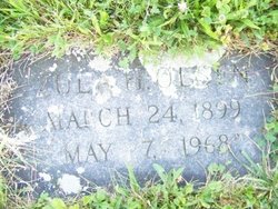

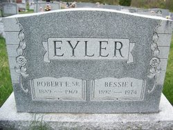
Zula Harbaugh Eyler Olsen
| Birth | : | 24 Mar 1899 Frederick County, Maryland, USA |
| Death | : | 7 May 1968 Cascade, Washington County, Maryland, USA |
| Burial | : | Monk Fryston Cemetery, Monk Fryston, Selby District, England |
| Coordinate | : | 53.7604400, -1.2291700 |
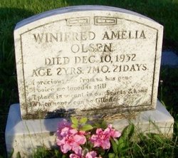
| Description | : | Children: (1.) Doris Evelyn Olson, married Frank Owen Moore Sr. (2.) Richard Olson. (3.) Thomas Olson. (4.) Everett Olson. (5.) Undine Olson Bennett. (6.) Winifred Amelia Olson, died young. |
frequently asked questions (FAQ):
-
Where is Zula Harbaugh Eyler Olsen's memorial?
Zula Harbaugh Eyler Olsen's memorial is located at: Monk Fryston Cemetery, Monk Fryston, Selby District, England.
-
When did Zula Harbaugh Eyler Olsen death?
Zula Harbaugh Eyler Olsen death on 7 May 1968 in Cascade, Washington County, Maryland, USA
-
Where are the coordinates of the Zula Harbaugh Eyler Olsen's memorial?
Latitude: 53.7604400
Longitude: -1.2291700
Family Members:
Parent

Spouse
Siblings
Children


Flowers:


Nearby Cemetories:
1. Monk Fryston Cemetery
Monk Fryston, Selby District, England
Coordinate: 53.7604400, -1.2291700
2. St Wilfrid’s Churchyard
Monk Fryston, Selby District, England
Coordinate: 53.7618300, -1.2349700
3. St Mary the Virgin Churchyard
South Milford, Selby District, England
Coordinate: 53.7771700, -1.2547300
4. St Mary Churchyard
Birkin, Selby District, England
Coordinate: 53.7325000, -1.1979000
5. St James Churchyard
Fairburn, Selby District, England
Coordinate: 53.7426700, -1.2841000
6. All Saints Churchyard
Sherburn-in-Elmet, Selby District, England
Coordinate: 53.7956000, -1.2605740
7. Brotherton United Reformed Church
Brotherton, Selby District, England
Coordinate: 53.7277104, -1.2698131
8. Hambleton Cemetery
Hambleton, Selby District, England
Coordinate: 53.7715910, -1.1624600
9. St Mary Churchyard
Hambleton, Selby District, England
Coordinate: 53.7715910, -1.1624600
10. St Edward the Confessor Churchyard
Brotherton, Selby District, England
Coordinate: 53.7259200, -1.2709600
11. All Saints Churchyard
Ledsham, Metropolitan Borough of Leeds, England
Coordinate: 53.7622160, -1.3091920
12. St. Andrew's Old Churchyard
Ferrybridge, Metropolitan Borough of Wakefield, England
Coordinate: 53.7193380, -1.2748540
13. United Reformed Churchyard
Knottingley, Metropolitan Borough of Wakefield, England
Coordinate: 53.7104820, -1.2397270
14. St. Botolph Churchyard
Knottingley, Metropolitan Borough of Wakefield, England
Coordinate: 53.7108080, -1.2441680
15. Ropewalk Methodist Church Burial Ground
Knottingley, Metropolitan Borough of Wakefield, England
Coordinate: 53.7092850, -1.2408320
16. St. Peter's Churchyard
Fryston, Metropolitan Borough of Wakefield, England
Coordinate: 53.7355400, -1.3151100
17. St. Edmund's Churchyard
Kellington, Selby District, England
Coordinate: 53.7142600, -1.1710500
18. Ferrybridge Cemetery
Ferrybridge, Metropolitan Borough of Wakefield, England
Coordinate: 53.7102530, -1.2795200
19. Knottingley Cemetery
Knottingley, Metropolitan Borough of Wakefield, England
Coordinate: 53.7018600, -1.2363390
20. Holy Trinity Churchyard
Barkston Ash, Selby District, England
Coordinate: 53.8189530, -1.2547620
21. St Mary the Virgin Churchyard
Church Fenton, Selby District, England
Coordinate: 53.8243100, -1.2203500
22. St. Mary the Virgin Churchyard
Micklefield, Metropolitan Borough of Leeds, England
Coordinate: 53.7971300, -1.3313700
23. All Saints Churchyard
Saxton, Selby District, England
Coordinate: 53.8261760, -1.2787060
24. Castleford New Extension Cemetery
Castleford, Metropolitan Borough of Wakefield, England
Coordinate: 53.7277600, -1.3391000