
| Memorials | : | 0 |
| Location | : | Armstrong County, USA |
| Coordinate | : | 40.8475000, -79.4747000 |
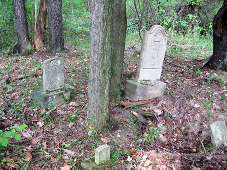
| Description | : | This is a small private cemetery located in a rural area near the village of Spaces Corners. There are only four graves that are marked with headstones, as well as seven graves that appear to be marked with field stone markers. These seven suspected graves may or may not be actual graves. There are no known surviving records to verify who might be buried here, but there are reports of people being buried here that are not among those known to be buried here. This cemetery is very overgrown and it is possible that there might be undiscovered... Read More |
frequently asked questions (FAQ):
-
Where is Ritchison Farm Cemetery?
Ritchison Farm Cemetery is located at Armstrong County ,Pennsylvania ,USA.
-
Ritchison Farm Cemetery cemetery's updated grave count on graveviews.com?
0 memorials
-
Where are the coordinates of the Ritchison Farm Cemetery?
Latitude: 40.8475000
Longitude: -79.4747000
Nearby Cemetories:
1. Good Shepherd Cemetery
Fenelton, Butler County, USA
Coordinate: 40.8434590, -79.4741510
2. Pine Creek Baptist Church Cemetery
Kittanning, Armstrong County, USA
Coordinate: 40.8514748, -79.4601440
3. Myers-Patton Cemetery
Adrian, Armstrong County, USA
Coordinate: 40.8619270, -79.4972458
4. Lower Piney Cemetery
Armstrong County, USA
Coordinate: 40.8655920, -79.4395400
5. Saint Joseph Cemetery
Kittanning, Armstrong County, USA
Coordinate: 40.8266983, -79.5074997
6. Pine Creek Methodist Cemetery
Pine Furnace, Armstrong County, USA
Coordinate: 40.8497870, -79.4309590
7. County Home Cemetery
Armstrong County, USA
Coordinate: 40.8114710, -79.4842390
8. Saint Marys Cemetery
Kittanning, Armstrong County, USA
Coordinate: 40.8347015, -79.5239029
9. Kittanning Cemetery
Kittanning, Armstrong County, USA
Coordinate: 40.8231140, -79.5174340
10. Croyle Cemetery
Adrian, Armstrong County, USA
Coordinate: 40.8782997, -79.5108032
11. Mount Union Davis Cemetery
Armstrong County, USA
Coordinate: 40.8323850, -79.4236530
12. Old Kittanning Cemetery (Defunct)
Kittanning, Armstrong County, USA
Coordinate: 40.8183950, -79.5243840
13. Cochran Cemetery
Templeton, Armstrong County, USA
Coordinate: 40.8941994, -79.4582977
14. Mateer Cemetery
Armstrong County, USA
Coordinate: 40.8721000, -79.4175000
15. Mount Zion Presbyterian Cemetery
Boggs Township, Armstrong County, USA
Coordinate: 40.8717100, -79.4171980
16. John Cemetery
Frenchs Corners, Armstrong County, USA
Coordinate: 40.9003296, -79.4978409
17. Toy Family Cemetery
Adrian, Armstrong County, USA
Coordinate: 40.8971130, -79.5082120
18. Scott Fox Memorial Site
Kittanning, Armstrong County, USA
Coordinate: 40.8457580, -79.3972170
19. Limestone Church of God Cemetery
Adrian, Armstrong County, USA
Coordinate: 40.8968887, -79.5180740
20. Montgomeryville Baptist Church Cemetery
Adrian, Armstrong County, USA
Coordinate: 40.8866615, -79.5376434
21. Brush Valley Cemetery
Adrian, Armstrong County, USA
Coordinate: 40.9044000, -79.5062000
22. Rupp Lutheran Church Cemetery
Kittanning, Armstrong County, USA
Coordinate: 40.7866516, -79.4561920
23. Campbell Family Cemetery
Walkchalk, Armstrong County, USA
Coordinate: 40.8420610, -79.5586110
24. Crissman Family Cemetery
Adrian, Armstrong County, USA
Coordinate: 40.8877490, -79.5402750