
| Memorials | : | 0 |
| Location | : | Armstrong County, USA |
| Coordinate | : | 40.8655920, -79.4395400 |
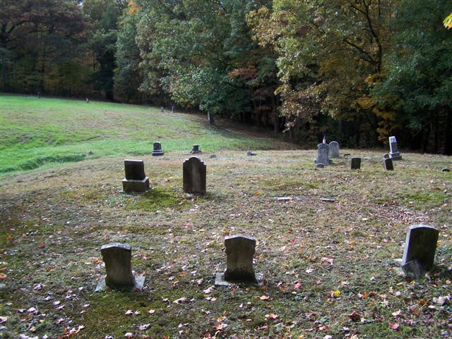
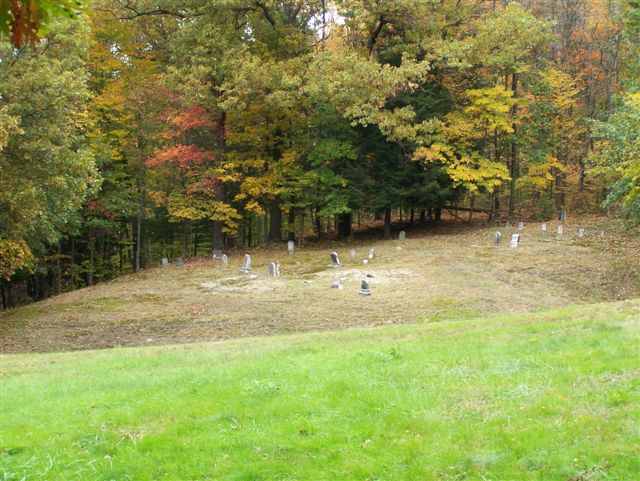
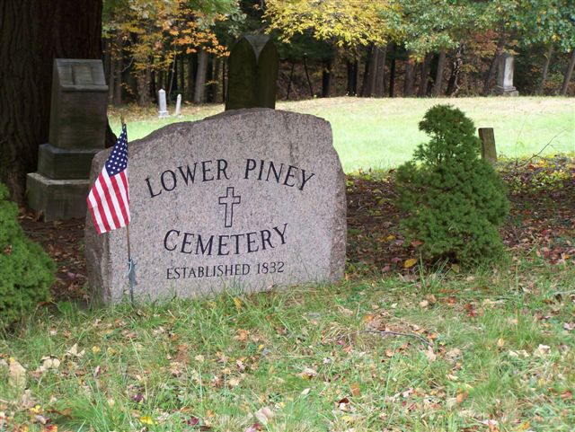
| Description | : | This cemetery was established in 1832 and most of the graves in the center of the cemetery are unmarked, or have washed out in one of the two ravines that bisect the graveyard. The cemetery is the burial place of Peter Brice, who, along with William Templeton and William Elliot were the original inhabitants of Pine Township. For many years, Peter P. Brice was head of the only Colored Family in this part of Western Pennsylvania. Brice arrived here in 1804 when the mouth of the Mahoning Creek and Allegheny River was an Indian Town of about 30 huts and... Read More |
frequently asked questions (FAQ):
-
Where is Lower Piney Cemetery?
Lower Piney Cemetery is located at Armstrong County ,Pennsylvania ,USA.
-
Lower Piney Cemetery cemetery's updated grave count on graveviews.com?
0 memorials
-
Where are the coordinates of the Lower Piney Cemetery?
Latitude: 40.8655920
Longitude: -79.4395400
Nearby Cemetories:
1. Pine Creek Methodist Cemetery
Pine Furnace, Armstrong County, USA
Coordinate: 40.8497870, -79.4309590
2. Mateer Cemetery
Armstrong County, USA
Coordinate: 40.8721000, -79.4175000
3. Mount Zion Presbyterian Cemetery
Boggs Township, Armstrong County, USA
Coordinate: 40.8717100, -79.4171980
4. Pine Creek Baptist Church Cemetery
Kittanning, Armstrong County, USA
Coordinate: 40.8514748, -79.4601440
5. Cochran Cemetery
Templeton, Armstrong County, USA
Coordinate: 40.8941994, -79.4582977
6. Ritchison Farm Cemetery
Armstrong County, USA
Coordinate: 40.8475000, -79.4747000
7. Good Shepherd Cemetery
Fenelton, Butler County, USA
Coordinate: 40.8434590, -79.4741510
8. Mount Union Davis Cemetery
Armstrong County, USA
Coordinate: 40.8323850, -79.4236530
9. Scott Fox Memorial Site
Kittanning, Armstrong County, USA
Coordinate: 40.8457580, -79.3972170
10. Myers-Patton Cemetery
Adrian, Armstrong County, USA
Coordinate: 40.8619270, -79.4972458
11. Calhoun Cemetery
Armstrong County, USA
Coordinate: 40.8502426, -79.3848648
12. Croyle Cemetery
Adrian, Armstrong County, USA
Coordinate: 40.8782997, -79.5108032
13. John Cemetery
Frenchs Corners, Armstrong County, USA
Coordinate: 40.9003296, -79.4978409
14. Rehobeth Reformed Presbyterian Church Cemetery
Kittanning, Armstrong County, USA
Coordinate: 40.8922670, -79.3695690
15. Toy Family Cemetery
Adrian, Armstrong County, USA
Coordinate: 40.8971130, -79.5082120
16. Bell Town Road Cemetery
Templeton, Armstrong County, USA
Coordinate: 40.9243110, -79.4624050
17. Brush Valley Cemetery
Adrian, Armstrong County, USA
Coordinate: 40.9044000, -79.5062000
18. County Home Cemetery
Armstrong County, USA
Coordinate: 40.8114710, -79.4842390
19. Saint Joseph Cemetery
Kittanning, Armstrong County, USA
Coordinate: 40.8266983, -79.5074997
20. Limestone Church of God Cemetery
Adrian, Armstrong County, USA
Coordinate: 40.8968887, -79.5180740
21. Stewardson Furnace Cemetery
Armstrong County, USA
Coordinate: 40.9331510, -79.4421280
22. Toy Cemetery
Reesedale, Armstrong County, USA
Coordinate: 40.9297750, -79.4706770
23. Saint Marys Cemetery
Kittanning, Armstrong County, USA
Coordinate: 40.8347015, -79.5239029
24. Kittanning Cemetery
Kittanning, Armstrong County, USA
Coordinate: 40.8231140, -79.5174340