
| Memorials | : | 3 |
| Location | : | Adrian, Armstrong County, USA |
| Coordinate | : | 40.8619270, -79.4972458 |
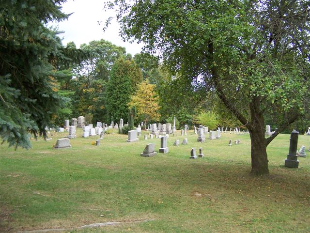
| Description | : | From downtown Kittanning, Armstrong County, Pennsylvania, cross the Allegheny River, on the Market Street Bridge, going in the direction away from the Courthouse and as you exit the bridge, turn immediately right, onto State Route 4023, also known as Tarrtown Road. On Tarrtown Road, drive North, for 4.81 miles, along the Western side of the Allegheny River, to the intersection at Quigley Hill Road. Turn Left onto Quigley Hill Road and drive up the steep hill for 0.25 miles. The Myers-Patton Cemetery is on the left, at the top of the hill, as you first see the fields. This cemetery has... Read More |
frequently asked questions (FAQ):
-
Where is Myers-Patton Cemetery?
Myers-Patton Cemetery is located at Adrian, Armstrong County ,Pennsylvania , 16210USA.
-
Myers-Patton Cemetery cemetery's updated grave count on graveviews.com?
3 memorials
-
Where are the coordinates of the Myers-Patton Cemetery?
Latitude: 40.8619270
Longitude: -79.4972458
Nearby Cemetories:
1. Croyle Cemetery
Adrian, Armstrong County, USA
Coordinate: 40.8782997, -79.5108032
2. Ritchison Farm Cemetery
Armstrong County, USA
Coordinate: 40.8475000, -79.4747000
3. Good Shepherd Cemetery
Fenelton, Butler County, USA
Coordinate: 40.8434590, -79.4741510
4. Pine Creek Baptist Church Cemetery
Kittanning, Armstrong County, USA
Coordinate: 40.8514748, -79.4601440
5. Saint Marys Cemetery
Kittanning, Armstrong County, USA
Coordinate: 40.8347015, -79.5239029
6. Saint Joseph Cemetery
Kittanning, Armstrong County, USA
Coordinate: 40.8266983, -79.5074997
7. Toy Family Cemetery
Adrian, Armstrong County, USA
Coordinate: 40.8971130, -79.5082120
8. Limestone Church of God Cemetery
Adrian, Armstrong County, USA
Coordinate: 40.8968887, -79.5180740
9. John Cemetery
Frenchs Corners, Armstrong County, USA
Coordinate: 40.9003296, -79.4978409
10. Montgomeryville Baptist Church Cemetery
Adrian, Armstrong County, USA
Coordinate: 40.8866615, -79.5376434
11. Crissman Family Cemetery
Adrian, Armstrong County, USA
Coordinate: 40.8877490, -79.5402750
12. Kittanning Cemetery
Kittanning, Armstrong County, USA
Coordinate: 40.8231140, -79.5174340
13. Brush Valley Cemetery
Adrian, Armstrong County, USA
Coordinate: 40.9044000, -79.5062000
14. Cochran Cemetery
Templeton, Armstrong County, USA
Coordinate: 40.8941994, -79.4582977
15. Lower Piney Cemetery
Armstrong County, USA
Coordinate: 40.8655920, -79.4395400
16. Saint Mark's Lutheran Church Cemetery
Adrian, Armstrong County, USA
Coordinate: 40.8960152, -79.5370865
17. Old Kittanning Cemetery (Defunct)
Kittanning, Armstrong County, USA
Coordinate: 40.8183950, -79.5243840
18. Campbell Family Cemetery
Walkchalk, Armstrong County, USA
Coordinate: 40.8420610, -79.5586110
19. County Home Cemetery
Armstrong County, USA
Coordinate: 40.8114710, -79.4842390
20. Pine Creek Methodist Cemetery
Pine Furnace, Armstrong County, USA
Coordinate: 40.8497870, -79.4309590
21. Fox Cemetery
East Franklin Township, Armstrong County, USA
Coordinate: 40.8388050, -79.5630550
22. Herron Family Cemetery
Cowansville, Armstrong County, USA
Coordinate: 40.8666170, -79.5751760
23. Mateer Cemetery
Armstrong County, USA
Coordinate: 40.8721000, -79.4175000
24. Mount Zion Presbyterian Cemetery
Boggs Township, Armstrong County, USA
Coordinate: 40.8717100, -79.4171980