
| Memorials | : | 1 |
| Location | : | Pine Furnace, Armstrong County, USA |
| Coordinate | : | 40.8497870, -79.4309590 |
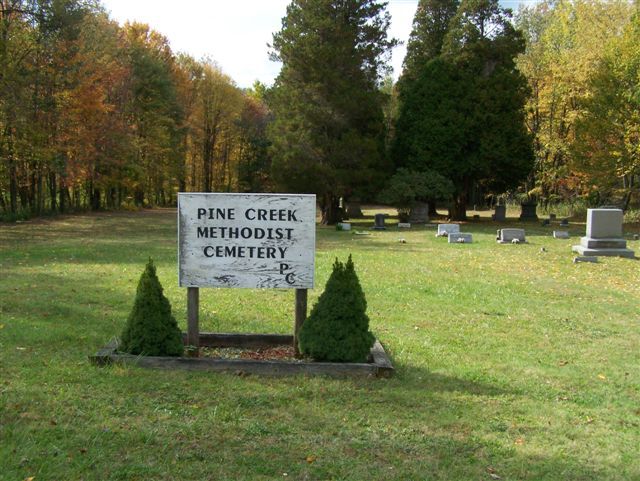
| Description | : | Also known as the Pine Furnace Methodist Church Cemetery. This cemetery is all that remains of the Pine Creek Methodist Church. At the beginning, it was a Methodist-Episcopal Church Service when it was first organized in 1846 and no one, to whom I have spoken, can tell me when it became just a Methodist Service. The original services were held in the Furnace School House, a 1000 feet to the northeast of the cemetery. The location of the Church was just South of the Old Furnace. On July 22, 1873, George Bossinger conveyed an acre from his farm... Read More |
frequently asked questions (FAQ):
-
Where is Pine Creek Methodist Cemetery?
Pine Creek Methodist Cemetery is located at Pine Furnace, Armstrong County ,Pennsylvania ,USA.
-
Pine Creek Methodist Cemetery cemetery's updated grave count on graveviews.com?
1 memorials
-
Where are the coordinates of the Pine Creek Methodist Cemetery?
Latitude: 40.8497870
Longitude: -79.4309590
Nearby Cemetories:
1. Lower Piney Cemetery
Armstrong County, USA
Coordinate: 40.8655920, -79.4395400
2. Mount Union Davis Cemetery
Armstrong County, USA
Coordinate: 40.8323850, -79.4236530
3. Pine Creek Baptist Church Cemetery
Kittanning, Armstrong County, USA
Coordinate: 40.8514748, -79.4601440
4. Mount Zion Presbyterian Cemetery
Boggs Township, Armstrong County, USA
Coordinate: 40.8717100, -79.4171980
5. Mateer Cemetery
Armstrong County, USA
Coordinate: 40.8721000, -79.4175000
6. Scott Fox Memorial Site
Kittanning, Armstrong County, USA
Coordinate: 40.8457580, -79.3972170
7. Ritchison Farm Cemetery
Armstrong County, USA
Coordinate: 40.8475000, -79.4747000
8. Good Shepherd Cemetery
Fenelton, Butler County, USA
Coordinate: 40.8434590, -79.4741510
9. Calhoun Cemetery
Armstrong County, USA
Coordinate: 40.8502426, -79.3848648
10. Cochran Cemetery
Templeton, Armstrong County, USA
Coordinate: 40.8941994, -79.4582977
11. Myers-Patton Cemetery
Adrian, Armstrong County, USA
Coordinate: 40.8619270, -79.4972458
12. County Home Cemetery
Armstrong County, USA
Coordinate: 40.8114710, -79.4842390
13. Salem United Church of Christ Cemetery
Kittanning, Armstrong County, USA
Coordinate: 40.8244130, -79.3559970
14. Simpson Church Cemetery
Kittanning, Armstrong County, USA
Coordinate: 40.7899000, -79.4083640
15. Saint Joseph Cemetery
Kittanning, Armstrong County, USA
Coordinate: 40.8266983, -79.5074997
16. Rehobeth Reformed Presbyterian Church Cemetery
Kittanning, Armstrong County, USA
Coordinate: 40.8922670, -79.3695690
17. Rupp Lutheran Church Cemetery
Kittanning, Armstrong County, USA
Coordinate: 40.7866516, -79.4561920
18. Elgin-Old Presbyterian Cemetery
Rural Valley, Armstrong County, USA
Coordinate: 40.8046646, -79.3662949
19. Croyle Cemetery
Adrian, Armstrong County, USA
Coordinate: 40.8782997, -79.5108032
20. Kittanning Cemetery
Kittanning, Armstrong County, USA
Coordinate: 40.8231140, -79.5174340
21. John Cemetery
Frenchs Corners, Armstrong County, USA
Coordinate: 40.9003296, -79.4978409
22. Saint Marys Cemetery
Kittanning, Armstrong County, USA
Coordinate: 40.8347015, -79.5239029
23. Pleasant Union Cemetery
Cowanshannock Township, Armstrong County, USA
Coordinate: 40.8314018, -79.3350449
24. Toy Family Cemetery
Adrian, Armstrong County, USA
Coordinate: 40.8971130, -79.5082120