
| Memorials | : | 0 |
| Location | : | Reesedale, Armstrong County, USA |
| Coordinate | : | 40.9379000, -79.4756000 |
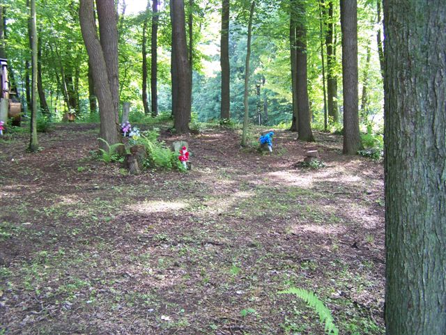
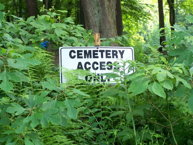
| Description | : | This cemetery is a very small family type cemetery with only about a half dozen to a dozen burials. There are only four markers here and a couple of them are illegible. Driving directions: Cross the bridge, in Kittanning, PA, driving in a direction away from the courthouse and at the far end of the bridge, turn right onto SR 4023 and drive NORTH, along the Allegheny River. Drive for a distance of 8.63 miles to the "T" intersection of Reesdale Road. Turn right onto Reesdale Rd and drive, for 1.86 miles, to the entrance of the... Read More |
frequently asked questions (FAQ):
-
Where is Walthour Cemetery?
Walthour Cemetery is located at Reesedale, Armstrong County ,Pennsylvania ,USA.
-
Walthour Cemetery cemetery's updated grave count on graveviews.com?
0 memorials
-
Where are the coordinates of the Walthour Cemetery?
Latitude: 40.9379000
Longitude: -79.4756000
Nearby Cemetories:
1. Toy Cemetery
Reesedale, Armstrong County, USA
Coordinate: 40.9297750, -79.4706770
2. Bell Town Road Cemetery
Templeton, Armstrong County, USA
Coordinate: 40.9243110, -79.4624050
3. Rimer Hill Cemetery
Armstrong County, USA
Coordinate: 40.9398130, -79.4990980
4. Stewardson Furnace Cemetery
Armstrong County, USA
Coordinate: 40.9331510, -79.4421280
5. Tidal Cemetery
Tidal, Armstrong County, USA
Coordinate: 40.9582520, -79.4990020
6. Old Earley Family Graveyard
Rimer, Armstrong County, USA
Coordinate: 40.9361115, -79.5255585
7. Brush Valley Cemetery
Adrian, Armstrong County, USA
Coordinate: 40.9044000, -79.5062000
8. John Cemetery
Frenchs Corners, Armstrong County, USA
Coordinate: 40.9003296, -79.4978409
9. Cochran Cemetery
Templeton, Armstrong County, USA
Coordinate: 40.8941994, -79.4582977
10. Toy Family Cemetery
Adrian, Armstrong County, USA
Coordinate: 40.8971130, -79.5082120
11. Bowser Cemetery
Morrows Corner, Armstrong County, USA
Coordinate: 40.9185070, -79.5341170
12. Kellersburg Lutheran Cemetery
Kellersburg, Armstrong County, USA
Coordinate: 40.9704000, -79.4244000
13. Duncan Cemetery
Armstrong County, USA
Coordinate: 40.9884750, -79.4727370
14. Limestone Church of God Cemetery
Adrian, Armstrong County, USA
Coordinate: 40.8968887, -79.5180740
15. Kellersburg Methodist Cemetery
Kellersburg, Armstrong County, USA
Coordinate: 40.9752000, -79.4240000
16. Saint Mary's Episcopal Cemetery
Armstrong County, USA
Coordinate: 40.9718630, -79.5398680
17. Sherrett Cemetery
Sherrett, Armstrong County, USA
Coordinate: 40.9329185, -79.5553360
18. Saint Mark's Lutheran Church Cemetery
Adrian, Armstrong County, USA
Coordinate: 40.8960152, -79.5370865
19. Lawsonham Cemetery
Rimersburg, Clarion County, USA
Coordinate: 41.0016000, -79.4872000
20. Deanville Cemetery
Deanville, Armstrong County, USA
Coordinate: 40.9517700, -79.3919170
21. Croyle Cemetery
Adrian, Armstrong County, USA
Coordinate: 40.8782997, -79.5108032
22. Reynolds Cemetery
Armstrong County, USA
Coordinate: 40.9789170, -79.5457850
23. Montgomeryville Baptist Church Cemetery
Adrian, Armstrong County, USA
Coordinate: 40.8866615, -79.5376434
24. Crissman Family Cemetery
Adrian, Armstrong County, USA
Coordinate: 40.8877490, -79.5402750