
| Memorials | : | 2 |
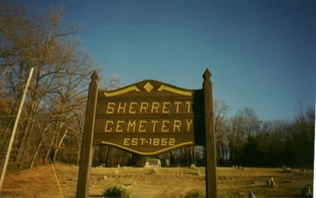
| Location | : | Sherrett, Armstrong County, USA |
| Coordinate | : | 40.9329185, -79.5553360 |
| Description | : | Driving Directions: This cemetery is located, on Sherrett Road, in the village of Sherrett, in Washington Township, Armstrong County, Pennsylvania and it is in the Cowansville, Pennsylvania zip code of 16218. In West Kittanning, Pennsylvania, at the intersection of Business U.S. Route 422 [Butler Road] and State Route 268 [E. Brady Road] drive north and west, on 268 for 6.54 miles to the intersection of SR 4017. [There is a Bar and an out of business BP Station, at this intersection] At the Bar, turn right onto SR 4017, and drive 2.87 miles into the Village of Sherrett... Read More |
frequently asked questions (FAQ):
-
Where is Sherrett Cemetery?
Sherrett Cemetery is located at Sherrett, Armstrong County ,Pennsylvania ,USA.
-
Sherrett Cemetery cemetery's updated grave count on graveviews.com?
2 memorials
-
Where are the coordinates of the Sherrett Cemetery?
Latitude: 40.9329185
Longitude: -79.5553360
Nearby Cemetories:
1. Bowser Cemetery
Morrows Corner, Armstrong County, USA
Coordinate: 40.9185070, -79.5341170
2. Old Earley Family Graveyard
Rimer, Armstrong County, USA
Coordinate: 40.9361115, -79.5255585
3. Simpson Cemetery
Cowansville, Armstrong County, USA
Coordinate: 40.9092150, -79.5941450
4. Fair Cemetery
Cowansville, Armstrong County, USA
Coordinate: 40.8961334, -79.5667419
5. Saint Mark's Lutheran Church Cemetery
Adrian, Armstrong County, USA
Coordinate: 40.8960152, -79.5370865
6. Saint Mary's Episcopal Cemetery
Armstrong County, USA
Coordinate: 40.9718630, -79.5398680
7. Rimer Hill Cemetery
Armstrong County, USA
Coordinate: 40.9398130, -79.4990980
8. Limestone Church of God Cemetery
Adrian, Armstrong County, USA
Coordinate: 40.8968887, -79.5180740
9. Reynolds Cemetery
Armstrong County, USA
Coordinate: 40.9789170, -79.5457850
10. Crissman Family Cemetery
Adrian, Armstrong County, USA
Coordinate: 40.8877490, -79.5402750
11. Brush Valley Cemetery
Adrian, Armstrong County, USA
Coordinate: 40.9044000, -79.5062000
12. Wattersonville United Methodist Cemetery
Wattersonville, Armstrong County, USA
Coordinate: 40.9801410, -79.5540080
13. Montgomeryville Baptist Church Cemetery
Adrian, Armstrong County, USA
Coordinate: 40.8866615, -79.5376434
14. Rich Hill United Presbyterian Church Cemetery
Cowansville, Armstrong County, USA
Coordinate: 40.8916750, -79.5890490
15. Tidal Cemetery
Tidal, Armstrong County, USA
Coordinate: 40.9582520, -79.4990020
16. Toy Family Cemetery
Adrian, Armstrong County, USA
Coordinate: 40.8971130, -79.5082120
17. Cowansville Cemetery
Cowansville, Armstrong County, USA
Coordinate: 40.8878860, -79.5878143
18. Phillipston Cemetery
Phillipston, Clarion County, USA
Coordinate: 40.9807000, -79.5889000
19. John Cemetery
Frenchs Corners, Armstrong County, USA
Coordinate: 40.9003296, -79.4978409
20. Walthour Cemetery
Reesedale, Armstrong County, USA
Coordinate: 40.9379000, -79.4756000
21. Saint Eusebius Cemetery
East Brady, Clarion County, USA
Coordinate: 40.9857620, -79.5991440
22. Toy Cemetery
Reesedale, Armstrong County, USA
Coordinate: 40.9297750, -79.4706770
23. Croyle Cemetery
Adrian, Armstrong County, USA
Coordinate: 40.8782997, -79.5108032
24. Herron Family Cemetery
Cowansville, Armstrong County, USA
Coordinate: 40.8666170, -79.5751760