
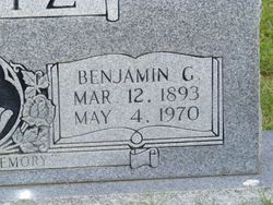

Benjamin Grover “Bennie” Wertz
| Birth | : | 12 Mar 1893 Elloree, Orangeburg County, South Carolina, USA |
| Death | : | 4 May 1970 Charleston, Charleston County, South Carolina, USA |
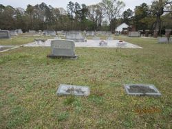
| Burial | : | Northfield Farms Cemetery, Northfield, Franklin County, USA |
| Coordinate | : | 42.6124992, -72.4741974 |
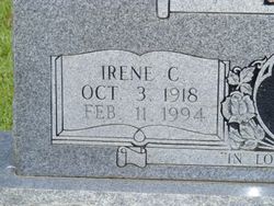
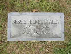
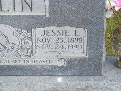
| Description | : | Benjamin Grover Wertz of 1864 Cornish Ave., retired mechanic with S. C. Electric and Gas Co., died Monday in a local hospital. Funeral services will be Wednesday at 11 a.m. at Stuhr's Downtown Funeral Chapel. Burial will be in Santee Cemetery, Elloree. Mr. Wertz was born in Elloree march 12, 1893. He was a Baptist. Surviving are his widow, Mrs. Irene Carter Wertz; four daughters, Mrs. Tony M. Jordan, Mrs. John J. Benton, Mrs. Patricia W. Milner and Mrs. Danny F. Hartline; all of James Island; three sisters, Mrs. Jessie Polin, Mrs. Hassie McEachern and Mrs. Bessie Staley, all of... Read More |
frequently asked questions (FAQ):
-
Where is Benjamin Grover “Bennie” Wertz's memorial?
Benjamin Grover “Bennie” Wertz's memorial is located at: Northfield Farms Cemetery, Northfield, Franklin County, USA.
-
When did Benjamin Grover “Bennie” Wertz death?
Benjamin Grover “Bennie” Wertz death on 4 May 1970 in Charleston, Charleston County, South Carolina, USA
-
Where are the coordinates of the Benjamin Grover “Bennie” Wertz's memorial?
Latitude: 42.6124992
Longitude: -72.4741974
Family Members:
Parent

Spouse
Siblings

Children
Flowers:


Nearby Cemetories:
1. Northfield Farms Cemetery
Northfield, Franklin County, USA
Coordinate: 42.6124992, -72.4741974
2. Durkee Burial Lot
Northfield, Franklin County, USA
Coordinate: 42.6070000, -72.4861000
3. Holton Cemetery
Erving, Franklin County, USA
Coordinate: 42.5799500, -72.4634600
4. Gill Center Cemetery
Gill, Franklin County, USA
Coordinate: 42.6413803, -72.4983063
5. Diemand Family Cemetery
Wendell, Franklin County, USA
Coordinate: 42.5769900, -72.4520600
6. North Cemetery
Gill, Franklin County, USA
Coordinate: 42.6514160, -72.4817630
7. Beers Ambush Gravesite
Northfield, Franklin County, USA
Coordinate: 42.6501200, -72.4560300
8. East Mineral Road Cemetery
Montague, Franklin County, USA
Coordinate: 42.5810500, -72.5086300
9. Highland Cemetery
Montague, Franklin County, USA
Coordinate: 42.5778008, -72.5083008
10. South Mountain Road Cemetery
Northfield, Franklin County, USA
Coordinate: 42.6375008, -72.4167023
11. Riverside Cemetery
Gill, Franklin County, USA
Coordinate: 42.6156006, -72.5410995
12. West Gill Cemetery
Gill, Franklin County, USA
Coordinate: 42.6442700, -72.5280500
13. Erving Center Cemetery
Erving, Franklin County, USA
Coordinate: 42.6033300, -72.4056800
14. Dry Hill Cemetery
Montague, Franklin County, USA
Coordinate: 42.5558300, -72.4647600
15. Town Cemetery
Montague, Franklin County, USA
Coordinate: 42.5595000, -72.5070200
16. Our Lady of Czestochowa Cemetery
Montague, Franklin County, USA
Coordinate: 42.5846000, -72.5469400
17. Saint Annes Cemetery
Montague, Franklin County, USA
Coordinate: 42.5861300, -72.5480600
18. Saint Marys Cemetery
Montague, Franklin County, USA
Coordinate: 42.5852200, -72.5475100
19. Aaron Clark Memorial Cemetery
Montague, Franklin County, USA
Coordinate: 42.5836200, -72.5471600
20. Springdale Cemetery
Montague, Franklin County, USA
Coordinate: 42.5884700, -72.5530900
21. Mount Hermon Cemetery
Northfield, Franklin County, USA
Coordinate: 42.6790800, -72.4821100
22. Fairway Avenue Cemetery
Montague, Franklin County, USA
Coordinate: 42.5924270, -72.5646970
23. Greenfield Hebrew Congregation Cemetery
Greenfield, Franklin County, USA
Coordinate: 42.6409410, -72.5653360
24. Coller Cemetery
Northfield, Franklin County, USA
Coordinate: 42.6563988, -72.3930969