
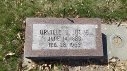
| Birth | : | 28 Aug 1896 McCool Junction, York County, Nebraska, USA |
| Death | : | 4 Sep 1954 Ottumwa, Wapello County, Iowa, USA |
| Burial | : | St. Nicholas Churchyard, Ash, Dover District, England |
| Coordinate | : | 51.2786800, 1.2786400 |
| Description | : | Earl was actually born August 28, 1892. He and his brother Ernest were twins. ---------- Earl Jacks, 58, of 105 South Van Buren avenue, died at the St. Joseph Hospital at 7:05 a.m. today. He been custodian at the local American Legion Post since 1946. Prior to that time he had been an employee of John Morrell & Co. for 15 years. The son of Isaac and Anna B. McCoy Jacks, he was born August 28, 1896, at McCool Junction, Neb. He had been a resident of Ottumwa for the past 26 years. His marriage to Daisy Riley took place July 5, 1929, at Fairfield. She... Read More |
frequently asked questions (FAQ):
-
Where is Earl E Jacks's memorial?
Earl E Jacks's memorial is located at: St. Nicholas Churchyard, Ash, Dover District, England.
-
When did Earl E Jacks death?
Earl E Jacks death on 4 Sep 1954 in Ottumwa, Wapello County, Iowa, USA
-
Where are the coordinates of the Earl E Jacks's memorial?
Latitude: 51.2786800
Longitude: 1.2786400
Family Members:
Parent
Spouse

Siblings
Children
Flowers:


Nearby Cemetories:
1. St. Nicholas Churchyard
Ash, Dover District, England
Coordinate: 51.2786800, 1.2786400
2. St James the Great Churchyard
Staple, Dover District, England
Coordinate: 51.2636300, 1.2515200
3. Saint Mary The Virgin Churchyard
Woodnesborough, Dover District, England
Coordinate: 51.2628240, 1.3073810
4. Elmstone Churchyard
Preston, Dover District, England
Coordinate: 51.2967160, 1.2424980
5. St .Mary's Churchyard
Sandwich, Dover District, England
Coordinate: 51.2771930, 1.3386580
6. St Mary the Virgin Churchyard
Eastry, Dover District, England
Coordinate: 51.2453000, 1.3100000
7. St. Peter's Churchyard
Sandwich, Dover District, England
Coordinate: 51.2747680, 1.3405120
8. St Clement's Church
Sandwich, Dover District, England
Coordinate: 51.2736510, 1.3427270
9. St Mary the Virgin Churchyard
Wingham, Dover District, England
Coordinate: 51.2721220, 1.2128950
10. St Mildred Churchyard
Preston, Dover District, England
Coordinate: 51.2985000, 1.2173980
11. St Clement Church
Knowlton, Dover District, England
Coordinate: 51.2348930, 1.2652130
12. Holy Cross
Goodnestone, Dover District, England
Coordinate: 51.2457190, 1.2290550
13. Church of Saint George at Ham
Eastry, Dover District, England
Coordinate: 51.2444830, 1.3319350
14. All Saints Churchyard
Stourmouth, Dover District, England
Coordinate: 51.3202600, 1.2365520
15. St Mary the Virgin Church
Minster-in-Thanet, Thanet District, England
Coordinate: 51.3305810, 1.3156720
16. St Mary the Virgin Churchyard
Betteshanger, Dover District, England
Coordinate: 51.2251200, 1.3118800
17. St Andrew Churchyard
Wickhambreaux, City of Canterbury, England
Coordinate: 51.2844400, 1.1822300
18. St Mary the Virgin Churchyard
Nonington, Dover District, England
Coordinate: 51.2258300, 1.2253800
19. Stodmarsh St Marys Churchyard
Wickhambreaux, City of Canterbury, England
Coordinate: 51.3009500, 1.1836900
20. Saint Andrew Churchyard
Tilmanstone, Dover District, England
Coordinate: 51.2159790, 1.2950400
21. Holy Innocents Churchyard
Adisham, City of Canterbury, England
Coordinate: 51.2440380, 1.1903320
22. Minster Cemetery
Minster-in-Thanet, Thanet District, England
Coordinate: 51.3423100, 1.3160550
23. St Augustine Churchyard
Northbourne, Dover District, England
Coordinate: 51.2221700, 1.3403500
24. St Nicholas’ Barfrestone Church Burial Ground
Eythorne, Dover District, England
Coordinate: 51.2056350, 1.2400870