John Dadds
| Birth | : | Apr 1834 St Nicholas at Wade, Thanet District, Kent, England |
| Death | : | 1 Jan 1863 Hythe, Shepway District, Kent, England |
| Burial | : | St Andrew Churchyard, Wickhambreaux, City of Canterbury, England |
| Coordinate | : | 51.2844400, 1.1822300 |
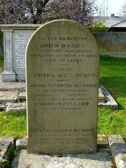
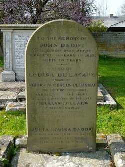
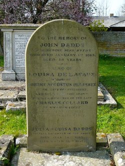
| Inscription | : | To the memory of JOHN DADDS Of Hergrove near Hythe who died January 1st 1863 aged 28 years |
| Description | : | Son of John and Sarah Dadds (nee Brice), John was a farmer. John was baptised on 16 April 1834 at St Nicholas at Wade, Thanet. He married Louisa Collard in 1861, in Bridge, Kent and they had two children. C1. Alice Matilda born in 1962 in Elham, Kent (see attached memorial) C2. Julia Louisa born in 1863 in Elham, Kent (see attached memorial) John was a farmer and he died at Hergrove, Newington near Hythe after a short illness aged just 28 years old. |
frequently asked questions (FAQ):
-
Where is John Dadds's memorial?
John Dadds's memorial is located at: St Andrew Churchyard, Wickhambreaux, City of Canterbury, England.
-
When did John Dadds death?
John Dadds death on 1 Jan 1863 in Hythe, Shepway District, Kent, England
-
Where are the coordinates of the John Dadds's memorial?
Latitude: 51.2844400
Longitude: 1.1822300
Family Members:
Spouse
Children
Flowers:
Nearby Cemetories:
1. Stodmarsh St Marys Churchyard
Wickhambreaux, City of Canterbury, England
Coordinate: 51.3009500, 1.1836900
2. St Mary the Virgin Churchyard
Wingham, Dover District, England
Coordinate: 51.2721220, 1.2128950
3. St Mildred Churchyard
Preston, Dover District, England
Coordinate: 51.2985000, 1.2173980
4. All Saints Churchyard
Westbere, City of Canterbury, England
Coordinate: 51.3065380, 1.1437670
5. St Mary the Virgin Churchyard
Fordwich, City of Canterbury, England
Coordinate: 51.2958300, 1.1270530
6. St Peter Churchyard
Bekesbourne, City of Canterbury, England
Coordinate: 51.2563430, 1.1445750
7. Elmstone Churchyard
Preston, Dover District, England
Coordinate: 51.2967160, 1.2424980
8. Sturry Cemetery
Sturry, City of Canterbury, England
Coordinate: 51.3058100, 1.1277700
9. Holy Innocents Churchyard
Adisham, City of Canterbury, England
Coordinate: 51.2440380, 1.1903320
10. St Nicholas Churchyard
Sturry, City of Canterbury, England
Coordinate: 51.2984830, 1.1201330
11. St Mary Churchyard
Patrixbourne, City of Canterbury, England
Coordinate: 51.2534430, 1.1364840
12. St James the Great Churchyard
Staple, Dover District, England
Coordinate: 51.2636300, 1.2515200
13. Holy Cross
Goodnestone, Dover District, England
Coordinate: 51.2457190, 1.2290550
14. All Saints Churchyard
Stourmouth, Dover District, England
Coordinate: 51.3202600, 1.2365520
15. St Mary The Virgin Churchyard
Chislet, City of Canterbury, England
Coordinate: 51.3343610, 1.1921020
16. St Peter Churchyard
Bridge, City of Canterbury, England
Coordinate: 51.2443730, 1.1271000
17. St Martin Churchyard
Canterbury, City of Canterbury, England
Coordinate: 51.2780170, 1.0937160
18. St Gregory Churchyard
Canterbury, City of Canterbury, England
Coordinate: 51.2816050, 1.0887840
19. St Augustine Abbey Ruins
Canterbury, City of Canterbury, England
Coordinate: 51.2781280, 1.0882060
20. St Mary Northgate Cemetery
Canterbury, City of Canterbury, England
Coordinate: 51.2811320, 1.0859300
21. St Gregory's Priory (defunct)
Canterbury, City of Canterbury, England
Coordinate: 51.2831127, 1.0855358
22. St. Nicholas Churchyard
Ash, Dover District, England
Coordinate: 51.2786800, 1.2786400
23. St Paul Without the Walls
Canterbury, City of Canterbury, England
Coordinate: 51.2779380, 1.0853180
24. St. John the Baptist Hospital Chapelyard
Canterbury, City of Canterbury, England
Coordinate: 51.2832713, 1.0837677


