
| Birth | : | 8 May 1932 Le Mars, Plymouth County, Iowa, USA |
| Death | : | 11 May 1995 Le Mars, Plymouth County, Iowa, USA |
| Burial | : | Holy Trinity Churchyard, Minchinhampton, Stroud District, England |
| Coordinate | : | 51.7063600, -2.1860700 |
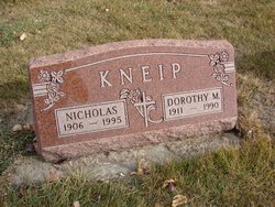
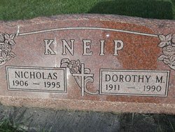
| Description | : | Loren J. Kneip, 63, of Oyens, died at his home following a brief illness. He is the son of Nicholas and Dorothy (Kunkel) Kneip. He served with the U.S. Army during the Korean War. Loren married Mary T. Kelly on September 9, 1952 in St. Catherine's Catholic Church in Oyens, Iowa. The couple farmed for several years west of Oyens. They moved to Le Mars in 1963. Loren then started a partnership as a carpenter with Redi-Bilt Homes, eventually taking over and operating the business for many years. Survivors include his wife, Mary; a son, John of Sioux City; a... Read More |
frequently asked questions (FAQ):
-
Where is Loren John Kneip's memorial?
Loren John Kneip's memorial is located at: Holy Trinity Churchyard, Minchinhampton, Stroud District, England.
-
When did Loren John Kneip death?
Loren John Kneip death on 11 May 1995 in Le Mars, Plymouth County, Iowa, USA
-
Where are the coordinates of the Loren John Kneip's memorial?
Latitude: 51.7063600
Longitude: -2.1860700
Family Members:
Parent
Spouse

Siblings


Children
Flowers:


Nearby Cemetories:
1. Holy Trinity Churchyard
Minchinhampton, Stroud District, England
Coordinate: 51.7063600, -2.1860700
2. Minchinhampton Baptist Churchyard
Minchinhampton, Stroud District, England
Coordinate: 51.7039614, -2.1853756
3. Brimscombe Cemetery
Brimscombe, Stroud District, England
Coordinate: 51.7165900, -2.1900600
4. St. Mary of the Angels Churchyard
Chalford, Stroud District, England
Coordinate: 51.7219000, -2.1708000
5. Holy Trinity Churchyard
Amberley, Stroud District, England
Coordinate: 51.7087660, -2.2177170
6. Amberley Church Cemetery
Amberley, Stroud District, England
Coordinate: 51.7091900, -2.2196100
7. Amberley Methodist Church - Littleworth Wesleyan C
Amberley, Stroud District, England
Coordinate: 51.7123580, -2.2202540
8. Christ Church Churchyard
Chalford, Stroud District, England
Coordinate: 51.7214500, -2.1577900
9. St. Michael's and All Angels Churchyard
Bisley, Stroud District, England
Coordinate: 51.7301150, -2.1715900
10. Holy Cross Churchyard
Avening, Cotswold District, England
Coordinate: 51.6806190, -2.1755620
11. Priory Church of the Annunciation Churchyard
Woodchester, Stroud District, England
Coordinate: 51.7080680, -2.2305250
12. France Lynch Congregational Chapelyard
Chalford, Stroud District, England
Coordinate: 51.7251000, -2.1485300
13. Chalford Baptist Tabernacle Churchyard
Chalford, Stroud District, England
Coordinate: 51.7226610, -2.1443260
14. Stroud Old Cemetery
Stroud, Stroud District, England
Coordinate: 51.7337658, -2.2094599
15. St. John the Baptist Churchyard
France Lynch, Stroud District, England
Coordinate: 51.7265600, -2.1445600
16. St Mary's Churchyard
Woodchester, Stroud District, England
Coordinate: 51.7224900, -2.2333920
17. Eastcombe Baptist Churchyard
Eastcombe, Stroud District, England
Coordinate: 51.7378009, -2.1606789
18. Stroud Hill Cemetery
Stroud, Stroud District, England
Coordinate: 51.7415670, -2.2002660
19. Rodborough Tabernacle
Rodborough, Stroud District, England
Coordinate: 51.7345300, -2.2245700
20. St. Mary Magdalene Churchyard
Rodborough, Stroud District, England
Coordinate: 51.7384180, -2.2284060
21. St Bartholemew Church
Oakridge, Stroud District, England
Coordinate: 51.7291209, -2.1276180
22. St. Laurence Churchyard
Stroud, Stroud District, England
Coordinate: 51.7459470, -2.2153950
23. All Saints Churchyard
Selsley, Stroud District, England
Coordinate: 51.7327800, -2.2487900
24. Kings Stanley Baptist Cemetery
Kings Stanley, Stroud District, England
Coordinate: 51.7269460, -2.2621780