

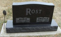
Marie Dumke Rost Eller
| Birth | : | 10 Jan 1924 Lincoln County, Minnesota, USA |
| Death | : | 30 Mar 2008 Clear Lake, Deuel County, South Dakota, USA |
| Burial | : | Archbold Cemetery, Archbold, Fulton County, USA |
| Coordinate | : | 41.5028000, -84.3058014 |
| Description | : | Mrs. Marie Rost Eller, age 84, of Clear Lake, SD passed away Sunday, March 30, 2008 at the Sanford Deuel County Medical Center in Clear Lake, SD. She was the widow of Ronald Eller and Dwain Rost. Marie was born January 10, 1924 to Henry J. and Bertha B. (Laabs) Dumke on the family farm near Lake Hendricks, MN. She attended the Goodview School District #53 country school near Brandt, SD. She was united in marriage to Dwain Rost on December 7, 1942 in Watertown, SD. Following their marriage, they lived and farmed near Gary, SD... Read More |
frequently asked questions (FAQ):
-
Where is Marie Dumke Rost Eller's memorial?
Marie Dumke Rost Eller's memorial is located at: Archbold Cemetery, Archbold, Fulton County, USA.
-
When did Marie Dumke Rost Eller death?
Marie Dumke Rost Eller death on 30 Mar 2008 in Clear Lake, Deuel County, South Dakota, USA
-
Where are the coordinates of the Marie Dumke Rost Eller's memorial?
Latitude: 41.5028000
Longitude: -84.3058014
Family Members:
Parent

Spouse

Siblings
Flowers:


Nearby Cemetories:
1. Archbold Cemetery
Archbold, Fulton County, USA
Coordinate: 41.5028000, -84.3058014
2. Reform Cemetery
Archbold, Fulton County, USA
Coordinate: 41.5039790, -84.3061070
3. Rupp Cemetery
Archbold, Fulton County, USA
Coordinate: 41.5140110, -84.2771370
4. Saint Peters Cemetery
Archbold, Fulton County, USA
Coordinate: 41.5428009, -84.2882996
5. Saint James Lutheran Cemetery
Burlington, Fulton County, USA
Coordinate: 41.5428009, -84.2630997
6. Saint John Lutheran Church Cemetery
Ridgeville Township, Henry County, USA
Coordinate: 41.4425410, -84.3084650
7. Pettisville Union Cemetery
Pettisville, Fulton County, USA
Coordinate: 41.5294190, -84.2258910
8. Pettisville Cemetery
Pettisville, Fulton County, USA
Coordinate: 41.5302620, -84.2258690
9. Aeschliman Cemetery
Pettisville, Fulton County, USA
Coordinate: 41.5147018, -84.2192001
10. Wyse Cemetery
Fulton County, USA
Coordinate: 41.5647820, -84.2686700
11. Pettisville Lutheran Cemetery
Pettisville, Fulton County, USA
Coordinate: 41.5321900, -84.2237400
12. Beck Cemetery
Fulton County, USA
Coordinate: 41.5648620, -84.2682880
13. Goll Cemetery
Archbold, Fulton County, USA
Coordinate: 41.5558014, -84.3677979
14. Locust Grove Cemetery
Ridgeville Corners, Henry County, USA
Coordinate: 41.4389650, -84.2558060
15. Saint Peter Lutheran Cemetery
Ridgeville Township, Henry County, USA
Coordinate: 41.4389000, -84.2549973
16. Zion Lutheran Church Cemetery
Napoleon, Henry County, USA
Coordinate: 41.4414170, -84.2495930
17. Zion Cemetery
Williams County, USA
Coordinate: 41.4417000, -84.3628006
18. Eckley Cemetery
Eckley, Fulton County, USA
Coordinate: 41.5641600, -84.2491200
19. Lauber Hill Cemetery
Fulton County, USA
Coordinate: 41.5742410, -84.2681490
20. Lockport Cemetery
Stryker, Williams County, USA
Coordinate: 41.5466690, -84.3927765
21. Johnson Cemetery
Burlington, Fulton County, USA
Coordinate: 41.5791230, -84.3308020
22. Freedom Township Cemetery
Freedom Township, Henry County, USA
Coordinate: 41.4752970, -84.2069960
23. Saint Marks Lutheran Cemetery
Defiance, Defiance County, USA
Coordinate: 41.4129240, -84.3257920
24. Oakwood Cemetery
Stryker, Williams County, USA
Coordinate: 41.4978900, -84.4274700