


Ronald A Eller
| Birth | : | 22 Dec 1936 Fedora, Miner County, South Dakota, USA |
| Death | : | 4 Dec 2007 Clear Lake, Deuel County, South Dakota, USA |
| Burial | : | Archbold Cemetery, Archbold, Fulton County, USA |
| Coordinate | : | 41.5028000, -84.3058014 |
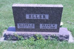
| Description | : | Ronald A. Eller December 22, 1936 - December 4, 2007 Ron was born on December 22, 1936 in Fedora, SD to Frank & Martha (Dahl) Eller. Ron went to school in Fedora and farmed with his dad until he was 18. Ron entered the United States Navy in 1955 and served in many countries during his tour. He retired from the military on August 15, 1977 and moved to Aurora, SD where he worked for Hoffman Furniture and the SCS office planting and cultivating trees. In 1986, Ron was united in marriage to Marie... Read More |
frequently asked questions (FAQ):
-
Where is Ronald A Eller's memorial?
Ronald A Eller's memorial is located at: Archbold Cemetery, Archbold, Fulton County, USA.
-
When did Ronald A Eller death?
Ronald A Eller death on 4 Dec 2007 in Clear Lake, Deuel County, South Dakota, USA
-
Where are the coordinates of the Ronald A Eller's memorial?
Latitude: 41.5028000
Longitude: -84.3058014
Family Members:
Parent

Spouse

Flowers:


Nearby Cemetories:
1. Archbold Cemetery
Archbold, Fulton County, USA
Coordinate: 41.5028000, -84.3058014
2. Reform Cemetery
Archbold, Fulton County, USA
Coordinate: 41.5039790, -84.3061070
3. Rupp Cemetery
Archbold, Fulton County, USA
Coordinate: 41.5140110, -84.2771370
4. Saint Peters Cemetery
Archbold, Fulton County, USA
Coordinate: 41.5428009, -84.2882996
5. Saint James Lutheran Cemetery
Burlington, Fulton County, USA
Coordinate: 41.5428009, -84.2630997
6. Saint John Lutheran Church Cemetery
Ridgeville Township, Henry County, USA
Coordinate: 41.4425410, -84.3084650
7. Pettisville Union Cemetery
Pettisville, Fulton County, USA
Coordinate: 41.5294190, -84.2258910
8. Pettisville Cemetery
Pettisville, Fulton County, USA
Coordinate: 41.5302620, -84.2258690
9. Aeschliman Cemetery
Pettisville, Fulton County, USA
Coordinate: 41.5147018, -84.2192001
10. Wyse Cemetery
Fulton County, USA
Coordinate: 41.5647820, -84.2686700
11. Pettisville Lutheran Cemetery
Pettisville, Fulton County, USA
Coordinate: 41.5321900, -84.2237400
12. Beck Cemetery
Fulton County, USA
Coordinate: 41.5648620, -84.2682880
13. Goll Cemetery
Archbold, Fulton County, USA
Coordinate: 41.5558014, -84.3677979
14. Locust Grove Cemetery
Ridgeville Corners, Henry County, USA
Coordinate: 41.4389650, -84.2558060
15. Saint Peter Lutheran Cemetery
Ridgeville Township, Henry County, USA
Coordinate: 41.4389000, -84.2549973
16. Zion Lutheran Church Cemetery
Napoleon, Henry County, USA
Coordinate: 41.4414170, -84.2495930
17. Zion Cemetery
Williams County, USA
Coordinate: 41.4417000, -84.3628006
18. Eckley Cemetery
Eckley, Fulton County, USA
Coordinate: 41.5641600, -84.2491200
19. Lauber Hill Cemetery
Fulton County, USA
Coordinate: 41.5742410, -84.2681490
20. Lockport Cemetery
Stryker, Williams County, USA
Coordinate: 41.5466690, -84.3927765
21. Johnson Cemetery
Burlington, Fulton County, USA
Coordinate: 41.5791230, -84.3308020
22. Freedom Township Cemetery
Freedom Township, Henry County, USA
Coordinate: 41.4752970, -84.2069960
23. Saint Marks Lutheran Cemetery
Defiance, Defiance County, USA
Coordinate: 41.4129240, -84.3257920
24. Oakwood Cemetery
Stryker, Williams County, USA
Coordinate: 41.4978900, -84.4274700