
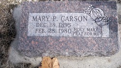
Mary Pauline Byrne Carson
| Birth | : | 18 Dec 1895 Pawnee County, Nebraska, USA |
| Death | : | 28 Feb 1980 |
| Burial | : | All Saints Churchyard, Lydd, Shepway District, England |
| Coordinate | : | 50.9518160, 0.9068730 |
| Description | : | Married to John Carson |
frequently asked questions (FAQ):
-
Where is Mary Pauline Byrne Carson's memorial?
Mary Pauline Byrne Carson's memorial is located at: All Saints Churchyard, Lydd, Shepway District, England.
-
When did Mary Pauline Byrne Carson death?
Mary Pauline Byrne Carson death on 28 Feb 1980 in
-
Where are the coordinates of the Mary Pauline Byrne Carson's memorial?
Latitude: 50.9518160
Longitude: 0.9068730
Family Members:
Parent

Spouse
Siblings
Children
Flowers:


Nearby Cemetories:
1. All Saints Churchyard
Lydd, Shepway District, England
Coordinate: 50.9518160, 0.9068730
2. Lydd Cemetery
Lydd, Shepway District, England
Coordinate: 50.9531810, 0.9127050
3. New Romney Cemetery
New Romney, Shepway District, England
Coordinate: 50.9843600, 0.9388800
4. St Clement Churchyard
Old Romney, Shepway District, England
Coordinate: 50.9901390, 0.8981780
5. Burma Campaign Memorial
New Romney, Shepway District, England
Coordinate: 50.9851600, 0.9404470
6. St Nicholas Churchyard
New Romney, Shepway District, England
Coordinate: 50.9850930, 0.9411740
7. St George's Church
Ivychurch, Shepway District, England
Coordinate: 51.0124590, 0.8895980
8. St Augustine Church
Brookland, Shepway District, England
Coordinate: 50.9973880, 0.8337460
9. St Mary the Virgin Churchyard
St Mary in the Marsh, Shepway District, England
Coordinate: 51.0141390, 0.9423380
10. Brenzett Cemetery
Brenzett, Shepway District, England
Coordinate: 51.0130800, 0.8561300
11. St Enswith's Church
Brenzett, Shepway District, England
Coordinate: 51.0138510, 0.8573170
12. St. Dunstan Churchyard
Snargate, Shepway District, England
Coordinate: 51.0227100, 0.8371750
13. St Augustine Church
Snave, Ashford Borough, England
Coordinate: 51.0334570, 0.8710390
14. St. Thomas à Becket Cemetery
Fairfield, Shepway District, England
Coordinate: 51.0043210, 0.7993930
15. Church of St. Peter & St. Paul
Newchurch, Shepway District, England
Coordinate: 51.0438640, 0.9272210
16. Holy Spirit Churchyard
Rye Harbour, Rother District, England
Coordinate: 50.9387970, 0.7567050
17. St Peter and St Paul Churchyard
Dymchurch, Shepway District, England
Coordinate: 51.0283830, 0.9979190
18. Dymchurch burial ground
Dymchurch, Shepway District, England
Coordinate: 51.0292430, 0.9972430
19. St Peter and St Paul Churchyard
Appledore, Ashford Borough, England
Coordinate: 51.0295660, 0.7903990
20. St Mary the Virgin Churchyard
Stone-cum-Ebony, Ashford Borough, England
Coordinate: 51.0127980, 0.7645592
21. St Mary the Virgin Churchyard
Rye, Rother District, England
Coordinate: 50.9501686, 0.7341530
22. St. Michael's Churchyard
Playden, Rother District, England
Coordinate: 50.9621200, 0.7327000
23. Rye Cemetery
Rye, Rother District, England
Coordinate: 50.9595370, 0.7322520
24. All Saints Churchyard
Burmarsh, Shepway District, England
Coordinate: 51.0492000, 0.9964000