
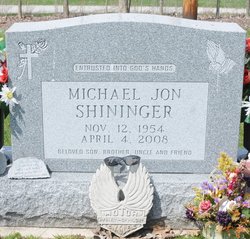
Michael Jon Shininger
| Birth | : | 12 Nov 1954 Willard, Huron County, Ohio, USA |
| Death | : | 4 Apr 2008 Willard, Huron County, Ohio, USA |
| Burial | : | Ss Peter and Paul Churchyard, Deddington, Cherwell District, England |
| Coordinate | : | 51.9817680, -1.3207470 |
| Inscription | : | Entrusted Into God's Hands Beloved Son, Brother, Uncle and Friend |
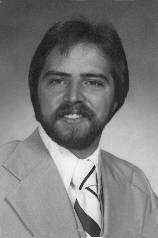
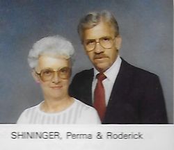
| Description | : | Willard Times-Junction, April 10, 2008 Michael Shininger Main St. Carry-Out Manager Michael Jon Shininger, age 53, resident of Willard, passed away on Friday, April 4, 2008 at Willard Mercy Hospital. He was born on November 12, 1954 to Roderick D. and Perma (Wenner) Shininger and had been a lifelong Willard resident. He was a 1973 graduate of Willard High School and a 1979 graduate of Kent State University. He was the manager of the Main Street Carry-Out in Willard. He was a member of the St. Francis Xavier Catholic Church, Commander of the Son's of the American Legion Post #514, a charter member... Read More |
frequently asked questions (FAQ):
-
Where is Michael Jon Shininger's memorial?
Michael Jon Shininger's memorial is located at: Ss Peter and Paul Churchyard, Deddington, Cherwell District, England.
-
When did Michael Jon Shininger death?
Michael Jon Shininger death on 4 Apr 2008 in Willard, Huron County, Ohio, USA
-
Where are the coordinates of the Michael Jon Shininger's memorial?
Latitude: 51.9817680
Longitude: -1.3207470
Family Members:
Parent
Flowers:


Nearby Cemetories:
1. Ss Peter and Paul Churchyard
Deddington, Cherwell District, England
Coordinate: 51.9817680, -1.3207470
2. Deddington Cemetery
Deddington, Cherwell District, England
Coordinate: 51.9824490, -1.3338930
3. St Marys Churchyard
North Aston, Cherwell District, England
Coordinate: 51.9562960, -1.3020350
4. St John's Churchyard
Barford St John, Cherwell District, England
Coordinate: 51.9955050, -1.3620350
5. St Mary Magdelene Churchyard
Duns Tew, Cherwell District, England
Coordinate: 51.9528350, -1.3363090
6. Barford St. Michael Churchyard
Barford St Michael, Cherwell District, England
Coordinate: 51.9903200, -1.3711500
7. Adderbury Parish Cemetery
Adderbury, Cherwell District, England
Coordinate: 52.0139537, -1.3246874
8. St Mary the Virgin Churchyard
Adderbury, Cherwell District, England
Coordinate: 52.0148420, -1.3152270
9. St John the Evangelist
Milton, Cherwell District, England
Coordinate: 52.0117900, -1.3452510
10. St James Churchyard
Somerton, Cherwell District, England
Coordinate: 51.9539990, -1.2786200
11. St James Churchyard
Nether Worton, West Oxfordshire District, England
Coordinate: 51.9678100, -1.3807900
12. Holy Trinity Churchyard
Over Worton, West Oxfordshire District, England
Coordinate: 51.9598240, -1.3753620
13. St Michael Churchyard
Aynho, South Northamptonshire Borough, England
Coordinate: 51.9936080, -1.2522380
14. Kings Sutton Cemetery
Kings Sutton, South Northamptonshire Borough, England
Coordinate: 52.0151400, -1.2711000
15. Ss Peter and Paul Churchyard
Kings Sutton, South Northamptonshire Borough, England
Coordinate: 52.0212000, -1.2763560
16. St Mary's Churchyard
Bloxham, Cherwell District, England
Coordinate: 52.0181100, -1.3748900
17. St Mary the Virgin Churchyard
Souldern, Cherwell District, England
Coordinate: 51.9808600, -1.2399900
18. SS Peter and Paul Churchyard
Steeple Aston, Cherwell District, England
Coordinate: 51.9311350, -1.3091000
19. Saint John the Baptist Churchyard
Bodicote, Cherwell District, England
Coordinate: 52.0356100, -1.3305700
20. Fritwell Parish Council Cemetery
Fritwell, Cherwell District, England
Coordinate: 51.9599490, -1.2380650
21. St Olave Churchyard
Fritwell, Cherwell District, England
Coordinate: 51.9596980, -1.2381180
22. South Newington St Peter ad Vincula
South Newington, Cherwell District, England
Coordinate: 51.9970000, -1.4082300
23. Saint Laurence Churchyard
Milcombe, Cherwell District, England
Coordinate: 52.0083060, -1.4033990
24. Upper Heyford Cemetery
Upper Heyford, Cherwell District, England
Coordinate: 51.9294701, -1.2808000