
| Memorials | : | 6 |
| Location | : | Fritwell, Cherwell District, England |
| Coordinate | : | 51.9596980, -1.2381180 |
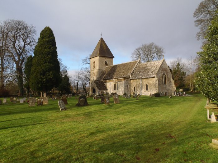
| Description | : | Also nearby is Fritwell Parish Council Cemetery. The earliest known written record of the Church of England parish church of Saint Olave is from 1103. The building was originally Norman, and the north and south doorways and original chancel arch survive from this time. Early in the 13th century the chancel was rebuilt and the bell-tower and south aisle and were added. The chancel retains two Early English Gothic lancet windows from this rebuilding. The Decorated Gothic north aisle was added later in the 13th or early in the 14th century and the Perpendicular Gothic clerestorey was added to the nave... Read More |
frequently asked questions (FAQ):
-
Where is St Olave Churchyard?
St Olave Churchyard is located at North Street Fritwell, Cherwell District ,Oxfordshire ,England.
-
St Olave Churchyard cemetery's updated grave count on graveviews.com?
6 memorials
-
Where are the coordinates of the St Olave Churchyard?
Latitude: 51.9596980
Longitude: -1.2381180
Nearby Cemetories:
1. Fritwell Parish Council Cemetery
Fritwell, Cherwell District, England
Coordinate: 51.9599490, -1.2380650
2. Fewcott All Saints Churchyard
Albury, South Oxfordshire District, England
Coordinate: 51.9477100, -1.2170700
3. St Mary the Virgin Churchyard
Souldern, Cherwell District, England
Coordinate: 51.9808600, -1.2399900
4. St. Mary's Churchyard
Ardley, Cherwell District, England
Coordinate: 51.9422140, -1.2122580
5. St James Churchyard
Somerton, Cherwell District, England
Coordinate: 51.9539990, -1.2786200
6. St Michael Churchyard
Aynho, South Northamptonshire Borough, England
Coordinate: 51.9936080, -1.2522380
7. St Peters Churchyard
Stoke Lyne, Cherwell District, England
Coordinate: 51.9505340, -1.1771680
8. St Marys Churchyard
North Aston, Cherwell District, England
Coordinate: 51.9562960, -1.3020350
9. Upper Heyford Cemetery
Upper Heyford, Cherwell District, England
Coordinate: 51.9294701, -1.2808000
10. St Marys Churchyard
Upper Heyford, Cherwell District, England
Coordinate: 51.9290710, -1.2819670
11. All Saints Churchyard
Croughton, South Northamptonshire Borough, England
Coordinate: 51.9977370, -1.2065760
12. St Peter's Churchyard
Bucknell, Cherwell District, England
Coordinate: 51.9263400, -1.1861700
13. Croughton Cemetery
Croughton, South Northamptonshire Borough, England
Coordinate: 52.0014880, -1.2031960
14. St Mary the Virgin Churchyard
Hardwick, Cherwell District, England
Coordinate: 51.9616750, -1.1615570
15. SS Peter and Paul Churchyard
Steeple Aston, Cherwell District, England
Coordinate: 51.9311350, -1.3091000
16. St Mary Churchyard
Lower Heyford, Cherwell District, England
Coordinate: 51.9202580, -1.2960220
17. All Saints Churchyard
Middleton Stoney, Cherwell District, England
Coordinate: 51.9053470, -1.2295300
18. Ss Peter and Paul Churchyard
Deddington, Cherwell District, England
Coordinate: 51.9817680, -1.3207470
19. Holy Trinity Churchyard
Hethe, Cherwell District, England
Coordinate: 51.9615600, -1.1452100
20. St. Mary's Churchyard
Cottisford, Cherwell District, England
Coordinate: 51.9749070, -1.1464410
21. Kings Sutton Cemetery
Kings Sutton, South Northamptonshire Borough, England
Coordinate: 52.0151400, -1.2711000
22. St Mary Magdelene Churchyard
Duns Tew, Cherwell District, England
Coordinate: 51.9528350, -1.3363090
23. St Leonard and St James Churchyard
Rousham, West Oxfordshire District, England
Coordinate: 51.9139780, -1.3037790
24. St. Edmund and St. George Churchyard
Hethe, Cherwell District, England
Coordinate: 51.9604830, -1.1384690