
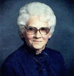

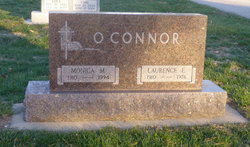
Monica Marcella Manion O'Connor
| Birth | : | 3 Aug 1910 Washington Township, Shelby County, Iowa, USA |
| Death | : | 24 Nov 1994 Dunlap, Harrison County, Iowa, USA |
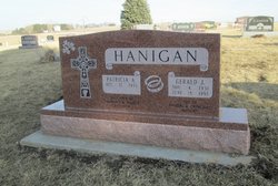
| Burial | : | Ss Peter and Paul Churchyard, Deddington, Cherwell District, England |
| Coordinate | : | 51.9817680, -1.3207470 |
frequently asked questions (FAQ):
-
Where is Monica Marcella Manion O'Connor's memorial?
Monica Marcella Manion O'Connor's memorial is located at: Ss Peter and Paul Churchyard, Deddington, Cherwell District, England.
-
When did Monica Marcella Manion O'Connor death?
Monica Marcella Manion O'Connor death on 24 Nov 1994 in Dunlap, Harrison County, Iowa, USA
-
Where are the coordinates of the Monica Marcella Manion O'Connor's memorial?
Latitude: 51.9817680
Longitude: -1.3207470
Family Members:
Parent

Spouse
Siblings
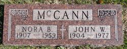
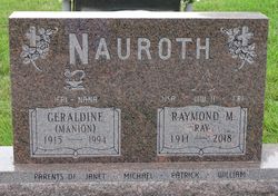

Children
Flowers:


Nearby Cemetories:
1. Ss Peter and Paul Churchyard
Deddington, Cherwell District, England
Coordinate: 51.9817680, -1.3207470
2. Deddington Cemetery
Deddington, Cherwell District, England
Coordinate: 51.9824490, -1.3338930
3. St Marys Churchyard
North Aston, Cherwell District, England
Coordinate: 51.9562960, -1.3020350
4. St John's Churchyard
Barford St John, Cherwell District, England
Coordinate: 51.9955050, -1.3620350
5. St Mary Magdelene Churchyard
Duns Tew, Cherwell District, England
Coordinate: 51.9528350, -1.3363090
6. Barford St. Michael Churchyard
Barford St Michael, Cherwell District, England
Coordinate: 51.9903200, -1.3711500
7. Adderbury Parish Cemetery
Adderbury, Cherwell District, England
Coordinate: 52.0139537, -1.3246874
8. St Mary the Virgin Churchyard
Adderbury, Cherwell District, England
Coordinate: 52.0148420, -1.3152270
9. St John the Evangelist
Milton, Cherwell District, England
Coordinate: 52.0117900, -1.3452510
10. St James Churchyard
Somerton, Cherwell District, England
Coordinate: 51.9539990, -1.2786200
11. St James Churchyard
Nether Worton, West Oxfordshire District, England
Coordinate: 51.9678100, -1.3807900
12. Holy Trinity Churchyard
Over Worton, West Oxfordshire District, England
Coordinate: 51.9598240, -1.3753620
13. St Michael Churchyard
Aynho, South Northamptonshire Borough, England
Coordinate: 51.9936080, -1.2522380
14. Kings Sutton Cemetery
Kings Sutton, South Northamptonshire Borough, England
Coordinate: 52.0151400, -1.2711000
15. Ss Peter and Paul Churchyard
Kings Sutton, South Northamptonshire Borough, England
Coordinate: 52.0212000, -1.2763560
16. St Mary's Churchyard
Bloxham, Cherwell District, England
Coordinate: 52.0181100, -1.3748900
17. St Mary the Virgin Churchyard
Souldern, Cherwell District, England
Coordinate: 51.9808600, -1.2399900
18. SS Peter and Paul Churchyard
Steeple Aston, Cherwell District, England
Coordinate: 51.9311350, -1.3091000
19. Saint John the Baptist Churchyard
Bodicote, Cherwell District, England
Coordinate: 52.0356100, -1.3305700
20. Fritwell Parish Council Cemetery
Fritwell, Cherwell District, England
Coordinate: 51.9599490, -1.2380650
21. St Olave Churchyard
Fritwell, Cherwell District, England
Coordinate: 51.9596980, -1.2381180
22. South Newington St Peter ad Vincula
South Newington, Cherwell District, England
Coordinate: 51.9970000, -1.4082300
23. Saint Laurence Churchyard
Milcombe, Cherwell District, England
Coordinate: 52.0083060, -1.4033990
24. Upper Heyford Cemetery
Upper Heyford, Cherwell District, England
Coordinate: 51.9294701, -1.2808000