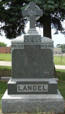
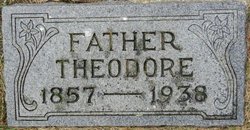
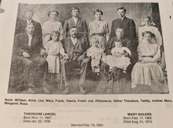
Theodore Langel
| Birth | : | 11 Nov 1857 Luxemburg, Dubuque County, Iowa, USA |
| Death | : | 22 Jan 1938 Plymouth County, Iowa, USA |
| Burial | : | Kerkhof NH Vaste Burchtker, Wijckel, De Fryske Marren Municipality, Netherlands |
| Coordinate | : | 52.8889630, 5.6246630 |
| Description | : | Le Mars Globe Post, IA, Monday, January 24, 1938, pg. 1, col. 3; pg. 2, col. 4 PIONEER SETTLER DIED SATURDAY Theo. Langel Passed Away At His Home Following Short Sickness The universal affection and esteem in which the late Theo Langel was held, was explained by an old neighbor as being the result of Mr. Langel's willingness to make personal sacrifices to help his friends, and never looking for credit. It was recalled that when there was an epidemic of very virulent diptheria in the 80's, causing numerous deaths, it was often impossible to get an... Read More |
frequently asked questions (FAQ):
-
Where is Theodore Langel's memorial?
Theodore Langel's memorial is located at: Kerkhof NH Vaste Burchtker, Wijckel, De Fryske Marren Municipality, Netherlands.
-
When did Theodore Langel death?
Theodore Langel death on 22 Jan 1938 in Plymouth County, Iowa, USA
-
Where are the coordinates of the Theodore Langel's memorial?
Latitude: 52.8889630
Longitude: 5.6246630
Family Members:
Parent
Spouse
Siblings
Children
Flowers:
Nearby Cemetories:
1. Kerkhof NH Vaste Burchtker
Wijckel, De Fryske Marren Municipality, Netherlands
Coordinate: 52.8889630, 5.6246630
2. Joodse Begraafplaats Tacozijl
Lemmer, De Fryske Marren Municipality, Netherlands
Coordinate: 52.8630740, 5.6452610
3. Natuurbegraafplaats Bremer Wildernis
Sondel, De Fryske Marren Municipality, Netherlands
Coordinate: 52.8714341, 5.5754786
4. Ijpecolsga General Cemetery
IJpecolsga, Sudwest Fryslan Municipality, Netherlands
Coordinate: 52.9344500, 5.6072800
5. Nijemirdum General Cemetery
Nijemirdum, De Fryske Marren Municipality, Netherlands
Coordinate: 52.8557700, 5.5669600
6. Lemmer General Cemetery
Lemmer, De Fryske Marren Municipality, Netherlands
Coordinate: 52.8479500, 5.7133100
7. Kerkhof Oudemirdum
Oudemirdum, De Fryske Marren Municipality, Netherlands
Coordinate: 52.8498364, 5.5332713
8. Idzega Klokkenstoel
Idzega, Sudwest Fryslan Municipality, Netherlands
Coordinate: 52.9775587, 5.5581642
9. Bakhuizen Roman Catholic Cemetery
Bakhuizen, De Fryske Marren Municipality, Netherlands
Coordinate: 52.8692200, 5.4557500
10. Koudum General Cemetery
Koudum, Sudwest Fryslan Municipality, Netherlands
Coordinate: 52.9114400, 5.4456200
11. Algemene bregraafplaats
Creil, Noordoostpolder Municipality, Netherlands
Coordinate: 52.7629574, 5.6640223
12. Westermeer Begraafplaats
Joure, De Fryske Marren Municipality, Netherlands
Coordinate: 52.9634300, 5.8033480
13. Molkwerum Protestant Churchyard
Molkwerum, Sudwest Fryslan Municipality, Netherlands
Coordinate: 52.9001600, 5.3992000
14. Workum Spoordyk General Cemetery
Workum, Sudwest Fryslan Municipality, Netherlands
Coordinate: 52.9749667, 5.4484889
15. Joodse Begraafplaats
Workum, Sudwest Fryslan Municipality, Netherlands
Coordinate: 52.9720900, 5.4353100
16. Workum Kerk
Workum, Sudwest Fryslan Municipality, Netherlands
Coordinate: 52.9789700, 5.4432000
17. Scharl General Cemetery
Skarl, Sudwest Fryslan Municipality, Netherlands
Coordinate: 52.8672300, 5.3909200
18. Rooms-Katholiek Kerkhof St. Vituskerk
Blauwhuis, Sudwest Fryslan Municipality, Netherlands
Coordinate: 53.0228265, 5.5340636
19. Hieslum Protestant Churchyard
Hieslum, Sudwest Fryslan Municipality, Netherlands
Coordinate: 53.0085400, 5.4884800
20. Hindeloopen Protestant Churchyard
Hindeloopen, Sudwest Fryslan Municipality, Netherlands
Coordinate: 52.9429100, 5.3984900
21. Oude Joodse Begraafplaats
Sneek, Sudwest Fryslan Municipality, Netherlands
Coordinate: 53.0362600, 5.6740600
22. Staveren General Cemetery
Stavoren, Sudwest Fryslan Municipality, Netherlands
Coordinate: 52.8820900, 5.3600500
23. Kuinre General Cemetery
Kuinre, Steenwijkerland Municipality, Netherlands
Coordinate: 52.7954100, 5.8393400
24. Begraafplaats van
Rottum, De Fryske Marren Municipality, Netherlands
Coordinate: 52.9368667, 5.8917667

