
| Birth | : | 7 Mar 1895 West Fork Township, Washington County, Arkansas, USA |
| Death | : | 4 Jan 1964 Fort Smith, Sebastian County, Arkansas, USA |
| Burial | : | Union Star Cemetery, West Fork, Washington County, USA |
| Coordinate | : | 35.8922005, -94.2031021 |
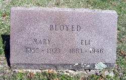
| Description | : | Arkansas, Death Certificates, 1914-1969: Name: Mrs Vinnie Irene Holcomb [Mrs Vinnie Irene Bloyed] Gender: Female Race: White Marital status: Widowed Age: 78 Birth Date: 7 May 1885 Birth Place: West Fork, Arkansas Death Date: 4 Jan 1964 Death Place: Fort Smith, Sebastian, Arkansas, USA Father: Ely Bloyed Mother: Mary Bloyed Burial: Union Star Cemetery Certificate Number: 001291 |
frequently asked questions (FAQ):
-
Where is Vinnie Irene Bloyed Holcomb's memorial?
Vinnie Irene Bloyed Holcomb's memorial is located at: Union Star Cemetery, West Fork, Washington County, USA.
-
When did Vinnie Irene Bloyed Holcomb death?
Vinnie Irene Bloyed Holcomb death on 4 Jan 1964 in Fort Smith, Sebastian County, Arkansas, USA
-
Where are the coordinates of the Vinnie Irene Bloyed Holcomb's memorial?
Latitude: 35.8922005
Longitude: -94.2031021
Family Members:
Parent

Spouse
Siblings
Flowers:


Nearby Cemetories:
1. Union Star Cemetery
West Fork, Washington County, USA
Coordinate: 35.8922005, -94.2031021
2. Friendship Cemetery
West Fork, Washington County, USA
Coordinate: 35.9043740, -94.2217230
3. Karnes Cemetery
West Fork, Washington County, USA
Coordinate: 35.9084930, -94.1865082
4. Low Gap Cemetery
West Fork, Washington County, USA
Coordinate: 35.8658218, -94.2063904
5. Burris Cemetery
Washington County, USA
Coordinate: 35.8935000, -94.2482650
6. Holcomb Cemetery
West Fork, Washington County, USA
Coordinate: 35.8954065, -94.2519087
7. West Fork Cemetery
West Fork, Washington County, USA
Coordinate: 35.9324989, -94.1932983
8. McClelland Cemetery
Washington County, USA
Coordinate: 35.8635950, -94.2410980
9. Phillips Cemetery
Hogeye, Washington County, USA
Coordinate: 35.9119760, -94.2556360
10. Old Bethlehem Baptist Church Cemetery
Washington County, USA
Coordinate: 35.8481865, -94.2252731
11. Carney Cemetery
Washington County, USA
Coordinate: 35.9242710, -94.2484530
12. Choate Cemetery
Onda, Washington County, USA
Coordinate: 35.8938200, -94.2732500
13. John A Rutherford - Martin Cemetery
Washington County, USA
Coordinate: 35.9513950, -94.2011490
14. Bryant Cemetery
Washington County, USA
Coordinate: 35.9514250, -94.2011060
15. Billingsley Cemetery
West Fork, Washington County, USA
Coordinate: 35.9132996, -94.2716980
16. McDonald Cemetery
Onda, Washington County, USA
Coordinate: 35.8806000, -94.2799988
17. John Westley Rutherford Cemetery
Washington County, USA
Coordinate: 35.9486760, -94.1669400
18. Mineral Springs Cemetery
West Fork, Washington County, USA
Coordinate: 35.9264980, -94.1349980
19. Howell Cemetery
Prairie Grove, Washington County, USA
Coordinate: 35.9056015, -94.2835999
20. Campbell Church Cemetery
West Fork, Washington County, USA
Coordinate: 35.9583015, -94.1903000
21. Reed Cemetery
West Fork, Washington County, USA
Coordinate: 35.9630800, -94.2051510
22. Parks Cemetery
Hogeye, Washington County, USA
Coordinate: 35.8988991, -94.2906036
23. Barron Cemetery
Greenland, Washington County, USA
Coordinate: 35.9599440, -94.2355570
24. Rutherford Cemetery
Prairie Grove, Washington County, USA
Coordinate: 35.9305992, -94.2825012