
| Memorials | : | 0 |
| Location | : | Independence, Kenton County, USA |
| Coordinate | : | 38.9260320, -84.5089030 |
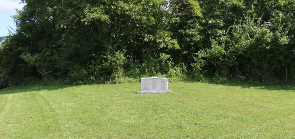
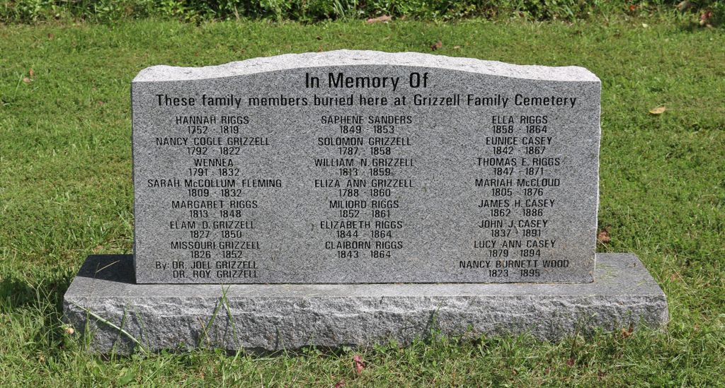
| Description | : | McCollum cemetery, also known as the Riggs-McCollum-Grizzel cemetery, is located on Marshall road, near Taylor Mill road in Independence, Kenton county, Kentucky. The cemetery is located on the south side of Marshall Road about 0.1 miles east of its intersection with Taylor Mill Road (Kentucky State Highway 16). A cemetery marker (latitude 38° 55’ 33.8” / longitude -84° 30’ 32.4”) sits on the west side of the cemetery in a grassy area. The cemetery proper is in a wooded area. The cemetery is listed as Riggs Cemetery on page 83 of Small Kenton County, Kentucky, Cemeteries, published... Read More |
frequently asked questions (FAQ):
-
Where is Grizzell Family Cemetery?
Grizzell Family Cemetery is located at 10979 Marshall Road Independence, Kenton County ,Kentucky , 41015USA.
-
Grizzell Family Cemetery cemetery's updated grave count on graveviews.com?
0 memorials
-
Where are the coordinates of the Grizzell Family Cemetery?
Latitude: 38.9260320
Longitude: -84.5089030
Nearby Cemetories:
1. Stephens Cemetery
Ryland Heights, Kenton County, USA
Coordinate: 38.9374570, -84.4977570
2. Hoffman Cemetery
Independence, Kenton County, USA
Coordinate: 38.9102777, -84.5200000
3. Faulkner Cemetery
Independence, Kenton County, USA
Coordinate: 38.9166670, -84.5333330
4. Petty Cemetery
Ryland, Kenton County, USA
Coordinate: 38.9391000, -84.4847100
5. Adams Cemetery
Visalia, Kenton County, USA
Coordinate: 38.9088889, -84.4861111
6. McCollum Cemetery
Independence, Kenton County, USA
Coordinate: 38.9431490, -84.5350520
7. Independence Cemetery
Independence, Kenton County, USA
Coordinate: 38.9364014, -84.5419006
8. Pruett - Mardis Cemetery
Independence, Kenton County, USA
Coordinate: 38.9463900, -84.4817100
9. Bird Cemetery
Independence, Kenton County, USA
Coordinate: 38.9027780, -84.5327780
10. Ashford Road Cemetery
Independence, Kenton County, USA
Coordinate: 38.9528850, -84.4892100
11. Saint Cecilias Cemetery
Independence, Kenton County, USA
Coordinate: 38.9397011, -84.5466995
12. Armstrong Cemetery #1
Nicholson, Kenton County, USA
Coordinate: 38.8961111, -84.5338889
13. Simmons Cemetery
Visalia, Kenton County, USA
Coordinate: 38.9069440, -84.4677780
14. Klette Cemetery
Latonia Lakes, Kenton County, USA
Coordinate: 38.9616670, -84.4944400
15. Minter Cemetery
Covington, Kenton County, USA
Coordinate: 38.9642300, -84.5055100
16. Pelly Cemetery
Latonia Lakes, Kenton County, USA
Coordinate: 38.9611110, -84.5294440
17. Osborn Cemetery
Latonia Lakes, Kenton County, USA
Coordinate: 38.9661110, -84.5016670
18. William Mardis Family Cemetery
Independence, Kenton County, USA
Coordinate: 38.9613800, -84.4800100
19. Lighthouse Memorial Gardens
Covington, Kenton County, USA
Coordinate: 38.9689350, -84.5025500
20. Callen Cemetery
Independence, Kenton County, USA
Coordinate: 38.8850000, -84.5266670
21. Oak Ridge Church Cemetery
Latonia Lakes, Kenton County, USA
Coordinate: 38.9691460, -84.5024180
22. Rector Cemetery
Atwood, Kenton County, USA
Coordinate: 38.8822900, -84.5001830
23. B'Hymer Cemetery
Independence, Kenton County, USA
Coordinate: 38.9525000, -84.5575000
24. Cox Cemetery
Covington, Kenton County, USA
Coordinate: 38.9716670, -84.5188890