
| Memorials | : | 0 |
| Location | : | Cowansville, Armstrong County, USA |
| Coordinate | : | 40.8666170, -79.5751760 |
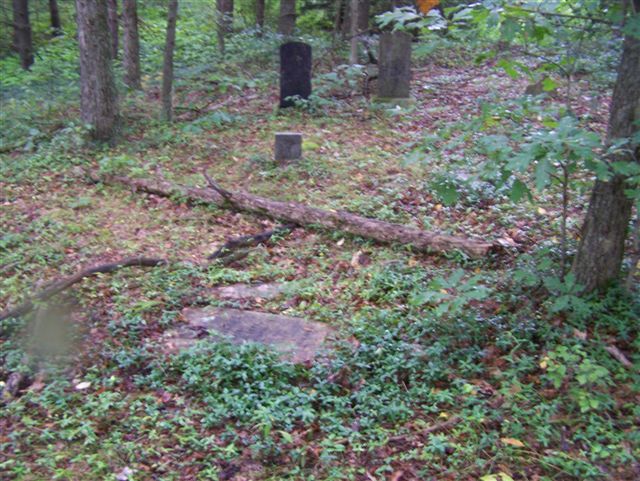
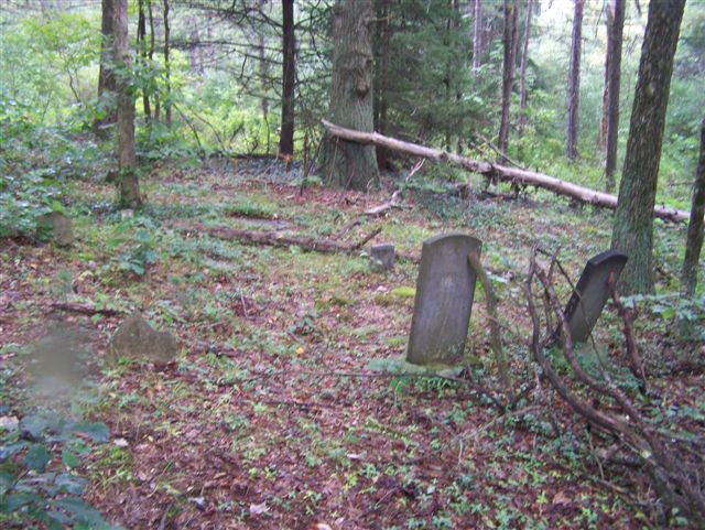
| Description | : | Russell Snyder, of the Cowansville, PA Cemetery Assn., informed me of this small family cemetery, in September 2009. He states that there are about 10 to 15 members of the Herron Family buried here and that they are the only ones who inhabit this cemetery. There are only two or three identifiable graves here and there are a small number of unmarked graves. This was an old farm, once owned by the Herrons and we are not privy to the land transactions after their demise. This land has been strip mined for coal, at some point... Read More |
frequently asked questions (FAQ):
-
Where is Herron Family Cemetery?
Herron Family Cemetery is located at Cowansville, Armstrong County ,Pennsylvania ,USA.
-
Herron Family Cemetery cemetery's updated grave count on graveviews.com?
0 memorials
-
Where are the coordinates of the Herron Family Cemetery?
Latitude: 40.8666170
Longitude: -79.5751760
Nearby Cemetories:
1. Cowansville Cemetery
Cowansville, Armstrong County, USA
Coordinate: 40.8878860, -79.5878143
2. Rich Hill United Presbyterian Church Cemetery
Cowansville, Armstrong County, USA
Coordinate: 40.8916750, -79.5890490
3. Campbell Family Cemetery
Walkchalk, Armstrong County, USA
Coordinate: 40.8420610, -79.5586110
4. Fox Cemetery
East Franklin Township, Armstrong County, USA
Coordinate: 40.8388050, -79.5630550
5. Fair Cemetery
Cowansville, Armstrong County, USA
Coordinate: 40.8961334, -79.5667419
6. Crissman Family Cemetery
Adrian, Armstrong County, USA
Coordinate: 40.8877490, -79.5402750
7. Montgomeryville Baptist Church Cemetery
Adrian, Armstrong County, USA
Coordinate: 40.8866615, -79.5376434
8. Saint Mark's Lutheran Church Cemetery
Adrian, Armstrong County, USA
Coordinate: 40.8960152, -79.5370865
9. West Glade Run Presbyterian Cemetery
Armstrong County, USA
Coordinate: 40.8225000, -79.5857000
10. Simpson Cemetery
Cowansville, Armstrong County, USA
Coordinate: 40.9092150, -79.5941450
11. Croyle Cemetery
Adrian, Armstrong County, USA
Coordinate: 40.8782997, -79.5108032
12. Saint Marys Cemetery
Kittanning, Armstrong County, USA
Coordinate: 40.8347015, -79.5239029
13. Limestone Church of God Cemetery
Adrian, Armstrong County, USA
Coordinate: 40.8968887, -79.5180740
14. Toy Family Cemetery
Adrian, Armstrong County, USA
Coordinate: 40.8971130, -79.5082120
15. Myers-Patton Cemetery
Adrian, Armstrong County, USA
Coordinate: 40.8619270, -79.4972458
16. Bowser Cemetery
Morrows Corner, Armstrong County, USA
Coordinate: 40.9185070, -79.5341170
17. Kittanning Cemetery
Kittanning, Armstrong County, USA
Coordinate: 40.8231140, -79.5174340
18. Old Kittanning Cemetery (Defunct)
Kittanning, Armstrong County, USA
Coordinate: 40.8183950, -79.5243840
19. Brush Valley Cemetery
Adrian, Armstrong County, USA
Coordinate: 40.9044000, -79.5062000
20. Saint Joseph Cemetery
Kittanning, Armstrong County, USA
Coordinate: 40.8266983, -79.5074997
21. John Cemetery
Frenchs Corners, Armstrong County, USA
Coordinate: 40.9003296, -79.4978409
22. Sherrett Cemetery
Sherrett, Armstrong County, USA
Coordinate: 40.9329185, -79.5553360
23. Center Hill Church of the Brethren Cemetery
Center Hill, Armstrong County, USA
Coordinate: 40.7962350, -79.5759060
24. Grace Brethren Church Cemetery
Center Hill, Armstrong County, USA
Coordinate: 40.7962720, -79.5785880