

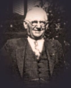
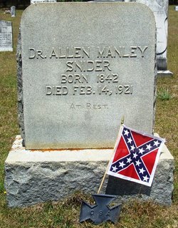
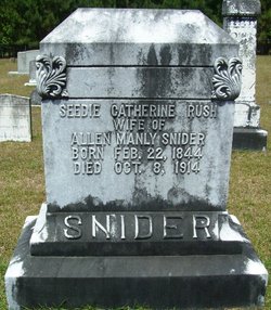
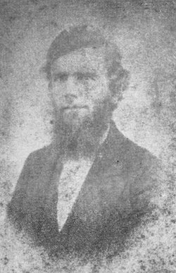
Dr Allen Manley Snider
| Birth | : | 6 Oct 1841 Orangeburg County, South Carolina, USA |
| Death | : | 14 Feb 1921 |
| Burial | : | Northfield Farms Cemetery, Northfield, Franklin County, USA |
| Coordinate | : | 42.6124992, -72.4741974 |
| Description | : | Allen Manley Snider enlisted at Camp Hampton near Columbia, SC on October 26, 1861. He was assigned to Company H, Infantry Regiment, Hampton Legion of South Carolina as a private. This company subsequently became Co. H. Mounted Infantry Regiment, Hampton Legion South Carolina Volunteers. Sergeant Snider rose to the rank of 2nd Lieutenant on 8th December, 1864. He was wounded at the battle of Newmarket Heights Va. in 1864 He was paroled at Appomattox Court House VA on April 10, 1865. Dr. Snider was the brother of William Judson Snider, founder of Elloree. He was an outstanding dentist in his... Read More |
frequently asked questions (FAQ):
-
Where is Dr Allen Manley Snider's memorial?
Dr Allen Manley Snider's memorial is located at: Northfield Farms Cemetery, Northfield, Franklin County, USA.
-
When did Dr Allen Manley Snider death?
Dr Allen Manley Snider death on 14 Feb 1921 in
-
Where are the coordinates of the Dr Allen Manley Snider's memorial?
Latitude: 42.6124992
Longitude: -72.4741974
Family Members:
Parent
Spouse
Siblings
Children

Flowers:


Nearby Cemetories:
1. Northfield Farms Cemetery
Northfield, Franklin County, USA
Coordinate: 42.6124992, -72.4741974
2. Durkee Burial Lot
Northfield, Franklin County, USA
Coordinate: 42.6070000, -72.4861000
3. Holton Cemetery
Erving, Franklin County, USA
Coordinate: 42.5799500, -72.4634600
4. Gill Center Cemetery
Gill, Franklin County, USA
Coordinate: 42.6413803, -72.4983063
5. Diemand Family Cemetery
Wendell, Franklin County, USA
Coordinate: 42.5769900, -72.4520600
6. North Cemetery
Gill, Franklin County, USA
Coordinate: 42.6514160, -72.4817630
7. Beers Ambush Gravesite
Northfield, Franklin County, USA
Coordinate: 42.6501200, -72.4560300
8. East Mineral Road Cemetery
Montague, Franklin County, USA
Coordinate: 42.5810500, -72.5086300
9. Highland Cemetery
Montague, Franklin County, USA
Coordinate: 42.5778008, -72.5083008
10. South Mountain Road Cemetery
Northfield, Franklin County, USA
Coordinate: 42.6375008, -72.4167023
11. Riverside Cemetery
Gill, Franklin County, USA
Coordinate: 42.6156006, -72.5410995
12. West Gill Cemetery
Gill, Franklin County, USA
Coordinate: 42.6442700, -72.5280500
13. Erving Center Cemetery
Erving, Franklin County, USA
Coordinate: 42.6033300, -72.4056800
14. Dry Hill Cemetery
Montague, Franklin County, USA
Coordinate: 42.5558300, -72.4647600
15. Town Cemetery
Montague, Franklin County, USA
Coordinate: 42.5595000, -72.5070200
16. Our Lady of Czestochowa Cemetery
Montague, Franklin County, USA
Coordinate: 42.5846000, -72.5469400
17. Saint Annes Cemetery
Montague, Franklin County, USA
Coordinate: 42.5861300, -72.5480600
18. Saint Marys Cemetery
Montague, Franklin County, USA
Coordinate: 42.5852200, -72.5475100
19. Aaron Clark Memorial Cemetery
Montague, Franklin County, USA
Coordinate: 42.5836200, -72.5471600
20. Springdale Cemetery
Montague, Franklin County, USA
Coordinate: 42.5884700, -72.5530900
21. Mount Hermon Cemetery
Northfield, Franklin County, USA
Coordinate: 42.6790800, -72.4821100
22. Fairway Avenue Cemetery
Montague, Franklin County, USA
Coordinate: 42.5924270, -72.5646970
23. Greenfield Hebrew Congregation Cemetery
Greenfield, Franklin County, USA
Coordinate: 42.6409410, -72.5653360
24. Coller Cemetery
Northfield, Franklin County, USA
Coordinate: 42.6563988, -72.3930969