Elizabeth Jane Kettner Straw
| Birth | : | 14 Feb 1850 Logan Mills, Clinton County, Pennsylvania, USA |
| Death | : | 3 Nov 1920 Okmulgee, Okmulgee County, Oklahoma, USA |
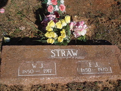
| Burial | : | Friendship Cemetery, West Fork, Washington County, USA |
| Coordinate | : | 35.9043740, -94.2217230 |
| Description | : | Andrew Jackson Straw's, funeral book list his mother Elizabeth died Nov 2, 1919. While other children list her death as listed above. Elizabeth was the wife of William Jackson Straw buried next to him in this cemetery. Elizabeth was the daughter of Andrew Kettner and Mary Jane Gladfelter/Glattfelter. Elizabeth had two children before she married William J.Straw. The first was a son named Lyman Owen Barner born in 1868 in Clinton County, Pennsylvania. He only used the name Owen. His last name was later changed to King. Elizabeth had a daughter named Minnie Elota King in 1871. Elizabeth was... Read More |
frequently asked questions (FAQ):
-
Where is Elizabeth Jane Kettner Straw's memorial?
Elizabeth Jane Kettner Straw's memorial is located at: Friendship Cemetery, West Fork, Washington County, USA.
-
When did Elizabeth Jane Kettner Straw death?
Elizabeth Jane Kettner Straw death on 3 Nov 1920 in Okmulgee, Okmulgee County, Oklahoma, USA
-
Where are the coordinates of the Elizabeth Jane Kettner Straw's memorial?
Latitude: 35.9043740
Longitude: -94.2217230
Family Members:
Parent
Spouse
Siblings
Children
Flowers:
Nearby Cemetories:
1. Friendship Cemetery
West Fork, Washington County, USA
Coordinate: 35.9043740, -94.2217230
2. Union Star Cemetery
West Fork, Washington County, USA
Coordinate: 35.8922005, -94.2031021
3. Burris Cemetery
Washington County, USA
Coordinate: 35.8935000, -94.2482650
4. Holcomb Cemetery
West Fork, Washington County, USA
Coordinate: 35.8954065, -94.2519087
5. Phillips Cemetery
Hogeye, Washington County, USA
Coordinate: 35.9119760, -94.2556360
6. Karnes Cemetery
West Fork, Washington County, USA
Coordinate: 35.9084930, -94.1865082
7. Carney Cemetery
Washington County, USA
Coordinate: 35.9242710, -94.2484530
8. West Fork Cemetery
West Fork, Washington County, USA
Coordinate: 35.9324989, -94.1932983
9. Low Gap Cemetery
West Fork, Washington County, USA
Coordinate: 35.8658218, -94.2063904
10. Billingsley Cemetery
West Fork, Washington County, USA
Coordinate: 35.9132996, -94.2716980
11. Choate Cemetery
Onda, Washington County, USA
Coordinate: 35.8938200, -94.2732500
12. McClelland Cemetery
Washington County, USA
Coordinate: 35.8635950, -94.2410980
13. John A Rutherford - Martin Cemetery
Washington County, USA
Coordinate: 35.9513950, -94.2011490
14. Bryant Cemetery
Washington County, USA
Coordinate: 35.9514250, -94.2011060
15. Howell Cemetery
Prairie Grove, Washington County, USA
Coordinate: 35.9056015, -94.2835999
16. McDonald Cemetery
Onda, Washington County, USA
Coordinate: 35.8806000, -94.2799988
17. Rutherford Cemetery
Prairie Grove, Washington County, USA
Coordinate: 35.9305992, -94.2825012
18. Parks Cemetery
Hogeye, Washington County, USA
Coordinate: 35.8988991, -94.2906036
19. Old Bethlehem Baptist Church Cemetery
Washington County, USA
Coordinate: 35.8481865, -94.2252731
20. Barron Cemetery
Greenland, Washington County, USA
Coordinate: 35.9599440, -94.2355570
21. Campbell Church Cemetery
West Fork, Washington County, USA
Coordinate: 35.9583015, -94.1903000
22. Stevenson Leach Cemetery
Prairie Grove, Washington County, USA
Coordinate: 35.9586000, -94.2524000
23. Reed Cemetery
West Fork, Washington County, USA
Coordinate: 35.9630800, -94.2051510
24. Sharp Cemetery
Prairie Grove, Washington County, USA
Coordinate: 35.9393997, -94.2827988


