
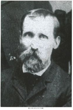


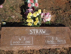
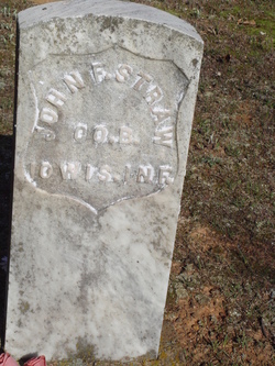
William Jackson Straw
| Birth | : | 15 Jun 1850 Hustisford, Dodge County, Wisconsin, USA |
| Death | : | 29 Oct 1917 Washington County, Arkansas, USA |
| Burial | : | Friendship Cemetery, West Fork, Washington County, USA |
| Coordinate | : | 35.9043740, -94.2217230 |
| Description | : | The photo that I added is from a family group photo taken in 1897. Minnie that is included in the group photo died in 1898. I believe this photo was taken the same time as the one I added to his mother Betsy Welch-Straw's memorial. I believe the rest of the families came to Iowa to celebrate Enoch and Betsy's anniversary and photos taken. Granted this is my opinion only. William Jackson Straw known as the General in the 1860 Hustisford, Dodge Co., Wisconsin census. Was the son of Enoch Straw and Betsy Welch. William was also called... Read More |
frequently asked questions (FAQ):
-
Where is William Jackson Straw's memorial?
William Jackson Straw's memorial is located at: Friendship Cemetery, West Fork, Washington County, USA.
-
When did William Jackson Straw death?
William Jackson Straw death on 29 Oct 1917 in Washington County, Arkansas, USA
-
Where are the coordinates of the William Jackson Straw's memorial?
Latitude: 35.9043740
Longitude: -94.2217230
Family Members:
Parent

Spouse
Siblings
Children
Flowers:


Nearby Cemetories:
1. Friendship Cemetery
West Fork, Washington County, USA
Coordinate: 35.9043740, -94.2217230
2. Union Star Cemetery
West Fork, Washington County, USA
Coordinate: 35.8922005, -94.2031021
3. Burris Cemetery
Washington County, USA
Coordinate: 35.8935000, -94.2482650
4. Holcomb Cemetery
West Fork, Washington County, USA
Coordinate: 35.8954065, -94.2519087
5. Phillips Cemetery
Hogeye, Washington County, USA
Coordinate: 35.9119760, -94.2556360
6. Karnes Cemetery
West Fork, Washington County, USA
Coordinate: 35.9084930, -94.1865082
7. Carney Cemetery
Washington County, USA
Coordinate: 35.9242710, -94.2484530
8. West Fork Cemetery
West Fork, Washington County, USA
Coordinate: 35.9324989, -94.1932983
9. Low Gap Cemetery
West Fork, Washington County, USA
Coordinate: 35.8658218, -94.2063904
10. Billingsley Cemetery
West Fork, Washington County, USA
Coordinate: 35.9132996, -94.2716980
11. Choate Cemetery
Onda, Washington County, USA
Coordinate: 35.8938200, -94.2732500
12. McClelland Cemetery
Washington County, USA
Coordinate: 35.8635950, -94.2410980
13. John A Rutherford - Martin Cemetery
Washington County, USA
Coordinate: 35.9513950, -94.2011490
14. Bryant Cemetery
Washington County, USA
Coordinate: 35.9514250, -94.2011060
15. Howell Cemetery
Prairie Grove, Washington County, USA
Coordinate: 35.9056015, -94.2835999
16. McDonald Cemetery
Onda, Washington County, USA
Coordinate: 35.8806000, -94.2799988
17. Rutherford Cemetery
Prairie Grove, Washington County, USA
Coordinate: 35.9305992, -94.2825012
18. Parks Cemetery
Hogeye, Washington County, USA
Coordinate: 35.8988991, -94.2906036
19. Old Bethlehem Baptist Church Cemetery
Washington County, USA
Coordinate: 35.8481865, -94.2252731
20. Barron Cemetery
Greenland, Washington County, USA
Coordinate: 35.9599440, -94.2355570
21. Campbell Church Cemetery
West Fork, Washington County, USA
Coordinate: 35.9583015, -94.1903000
22. Stevenson Leach Cemetery
Prairie Grove, Washington County, USA
Coordinate: 35.9586000, -94.2524000
23. Reed Cemetery
West Fork, Washington County, USA
Coordinate: 35.9630800, -94.2051510
24. Sharp Cemetery
Prairie Grove, Washington County, USA
Coordinate: 35.9393997, -94.2827988