
| Memorials | : | 0 |
| Location | : | Baunton, Cotswold District, England |
| Coordinate | : | 51.7400511, -1.9692225 |
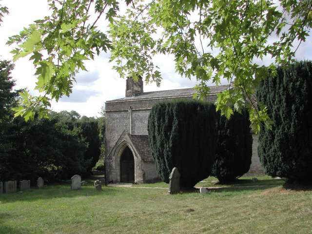
| Description | : | The church of St Mary Magdalene was built around 1150 by the monks of Cirencester Abbey. The Abbot of Cirencester was also the lord of the manor at Baunton, and the monks cultivated land here. The abbey retained ownership of the Baunton estate until the Dissolution of the Monasteries. |
frequently asked questions (FAQ):
-
Where is St Mary Magdalene Churchyard?
St Mary Magdalene Churchyard is located at Baunton, Cotswold District ,Gloucestershire ,England.
-
St Mary Magdalene Churchyard cemetery's updated grave count on graveviews.com?
0 memorials
-
Where are the coordinates of the St Mary Magdalene Churchyard?
Latitude: 51.7400511
Longitude: -1.9692225
Nearby Cemetories:
1. Stratton Cemetery
Cirencester, Cotswold District, England
Coordinate: 51.7353020, -1.9859041
2. St. John the Baptist Churchyard
Cirencester, Cotswold District, England
Coordinate: 51.7175600, -1.9678580
3. All Saints Churchyard
North Cerney, Cotswold District, England
Coordinate: 51.7687300, -1.9746800
4. Chesterton Cemetery
Cirencester, Cotswold District, England
Coordinate: 51.7099230, -1.9801340
5. St Mary Churchyard
Barnsley, Cotswold District, England
Coordinate: 51.7445030, -1.8894860
6. St Peter Churchyard
Duntisbourne Abbots, Cotswold District, England
Coordinate: 51.7694080, -2.0438190
7. St Matthew Churchyard
Coates, Cotswold District, England
Coordinate: 51.7077470, -2.0411010
8. Ampney St Peter Churchyard
Ampney St Peter, Cotswold District, England
Coordinate: 51.7126320, -1.8918160
9. Ampney St. Mary Parish Churchyard
Ampney St Mary, Cotswold District, England
Coordinate: 51.7125000, -1.8919000
10. St. Kenelm's Churchyard
Sapperton, Cotswold District, England
Coordinate: 51.7294000, -2.0775000
11. All Hallows Churchyard
South Cerney, Cotswold District, England
Coordinate: 51.6748248, -1.9292083
12. St Andrews
Chedworth, Cotswold District, England
Coordinate: 51.8078450, -1.9259590
13. All Saints Church
Kemble, Cotswold District, England
Coordinate: 51.6711000, -2.0154000
14. Poulton Priory
Poulton, Cotswold District, England
Coordinate: 51.6989750, -1.8638940
15. St. Mary the Virgin Churchyard
Bibury, Cotswold District, England
Coordinate: 51.7587037, -1.8376852
16. St. Mary the Virgin Churchyard
Syde, Cotswold District, England
Coordinate: 51.7961724, -2.0750209
17. St. Andrew's Churchyard
Miserden, Stroud District, England
Coordinate: 51.7787500, -2.0940500
18. St Peter Churchyard
Rodmarton, Cotswold District, England
Coordinate: 51.6812230, -2.0841920
19. Holy Cross Churchyard
Ashton Keynes, Wiltshire Unitary Authority, England
Coordinate: 51.6479000, -1.9394000
20. St Bartholemew Church
Oakridge, Stroud District, England
Coordinate: 51.7291209, -2.1276180
21. All Saints Churchyard
Down Ampney, Cotswold District, England
Coordinate: 51.6674850, -1.8592640
22. Saint Michael and All Angels Churchyard
Brimpsfield, Cotswold District, England
Coordinate: 51.8000000, -2.1000000
23. St. Mary's Churchyard
Cowley, Cotswold District, England
Coordinate: 51.8304330, -2.0520550
24. Bisley Burial Ground
Bisley, Stroud District, England
Coordinate: 51.7493640, -2.1389080