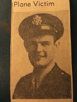
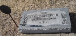
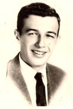
Lieut Jacob Dean Spohn
| Birth | : | 1921 |
| Death | : | 1946 |
| Burial | : | Lockport Cemetery, Stryker, Williams County, USA |
| Coordinate | : | 41.5466690, -84.3927765 |
| Inscription | : | A.T.G. |
| Description | : | Delpos Republican August 8, 1946 AIRPLANE CRASH NEAR TESCOTT FATAL TO TWO Jacob Dean Spohn, 25, of Culver, a former army air transport command pilot, was killed and his companion, Miss Mary Virginia Crider of Tescott fatally injured in an airplane crash two and one half miles west of Tescott Saturday evening. Spohn will be remmebered here as the pitcher who struck out 18 batters when he pitched for Tescott in the state tournament at Wichita recently against the Cessna Bobcats. Miss Crider was taken to Asbury Hospital in Salina where she died Tuesday morning. She was the only daughter of Mr.and... Read More |
frequently asked questions (FAQ):
-
Where is Lieut Jacob Dean Spohn's memorial?
Lieut Jacob Dean Spohn's memorial is located at: Lockport Cemetery, Stryker, Williams County, USA.
-
When did Lieut Jacob Dean Spohn death?
Lieut Jacob Dean Spohn death on 1946 in
-
Where are the coordinates of the Lieut Jacob Dean Spohn's memorial?
Latitude: 41.5466690
Longitude: -84.3927765
Family Members:
Parent
Siblings
Flowers:
Nearby Cemetories:
1. Lockport Cemetery
Stryker, Williams County, USA
Coordinate: 41.5466690, -84.3927765
2. Goll Cemetery
Archbold, Fulton County, USA
Coordinate: 41.5558014, -84.3677979
3. Floral Grove Cemetery
West Unity, Williams County, USA
Coordinate: 41.5708008, -84.4158020
4. Beatty Cemetery
West Unity, Williams County, USA
Coordinate: 41.5881970, -84.3954710
5. Bodel Cemetery
Stryker, Williams County, USA
Coordinate: 41.5277080, -84.4495600
6. Rings Cemetery
West Unity, Williams County, USA
Coordinate: 41.5928680, -84.4288400
7. Oakwood Cemetery
Stryker, Williams County, USA
Coordinate: 41.4978900, -84.4274700
8. Johnson Cemetery
Burlington, Fulton County, USA
Coordinate: 41.5791230, -84.3308020
9. French Cemetery
Springfield Township, Williams County, USA
Coordinate: 41.5039100, -84.4485500
10. Kunkle Cemetery
Williams County, USA
Coordinate: 41.5561150, -84.4762400
11. Ely Cemetery
West Unity, Williams County, USA
Coordinate: 41.6135630, -84.3939880
12. Quaker Cemetery
West Unity, Williams County, USA
Coordinate: 41.6155770, -84.3834280
13. West Franklin Cemetery
Fayette, Fulton County, USA
Coordinate: 41.6224400, -84.3940900
14. Boynton Cemetery
Stryker, Williams County, USA
Coordinate: 41.4782982, -84.4389038
15. Reform Cemetery
Archbold, Fulton County, USA
Coordinate: 41.5039790, -84.3061070
16. Saint Peters Cemetery
Archbold, Fulton County, USA
Coordinate: 41.5428009, -84.2882996
17. Archbold Cemetery
Archbold, Fulton County, USA
Coordinate: 41.5028000, -84.3058014
18. Ely Cemetery
Fayette, Fulton County, USA
Coordinate: 41.6255989, -84.3824997
19. Beaver Creek Cemetery
West Unity, Williams County, USA
Coordinate: 41.6011009, -84.4738998
20. Shiffler Cemetery
Jefferson Township, Williams County, USA
Coordinate: 41.5325012, -84.5063934
21. Williams County Infirmary Cemetery
West Unity, Williams County, USA
Coordinate: 41.5571430, -84.5097860
22. Bistline Cemetery
West Unity, Williams County, USA
Coordinate: 41.5995650, -84.4909490
23. Rupp Cemetery
Archbold, Fulton County, USA
Coordinate: 41.5140110, -84.2771370
24. Wyse Cemetery
Fulton County, USA
Coordinate: 41.5647820, -84.2686700

