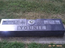
Richard H “Rich” Younie
| Birth | : | 16 Aug 1891 Sac County, Iowa, USA |
| Death | : | 9 Aug 1977 Santa Monica, Los Angeles County, California, USA |
| Burial | : | St Marys Churchyard, Broadwater, Worthing Borough, England |
| Coordinate | : | 50.8277750, -0.3734920 |
| Description | : | Rich was a farmer and they owned a farm North of Schaller which was farmed by the Lindgren Family but they always lived in Schaller. He was married to Eva Dibbern. After Eva died he went to live with his daughter, Mildren Sears, In Malibu, California and died there. |
frequently asked questions (FAQ):
-
Where is Richard H “Rich” Younie's memorial?
Richard H “Rich” Younie's memorial is located at: St Marys Churchyard, Broadwater, Worthing Borough, England.
-
When did Richard H “Rich” Younie death?
Richard H “Rich” Younie death on 9 Aug 1977 in Santa Monica, Los Angeles County, California, USA
-
Where are the coordinates of the Richard H “Rich” Younie's memorial?
Latitude: 50.8277750
Longitude: -0.3734920
Family Members:
Parent
Spouse
Siblings
Flowers:
Nearby Cemetories:
1. St Marys Churchyard
Broadwater, Worthing Borough, England
Coordinate: 50.8277750, -0.3734920
2. Broadwater Cemetery
Worthing, Worthing Borough, England
Coordinate: 50.8277650, -0.3799460
3. St Matthew Churchyard
Worthing, Worthing Borough, England
Coordinate: 50.8178900, -0.3830100
4. St Andrew the Apostle Churchyard
Worthing, Worthing Borough, England
Coordinate: 50.8153000, -0.3774100
5. The Catholic Church of Saint Charles Borromeo
Worthing Borough, England
Coordinate: 50.8206203, -0.3544798
6. St Andrew Churchyard
Tarring, Worthing Borough, England
Coordinate: 50.8247000, -0.3956000
7. St Mary of the Angels RC Church
Worthing, Worthing Borough, England
Coordinate: 50.8133800, -0.3774000
8. Christ Church Churchyard
Worthing, Worthing Borough, England
Coordinate: 50.8131570, -0.3739420
9. Holy Trinity Churchyard
Worthing, Worthing Borough, England
Coordinate: 50.8112700, -0.3785000
10. Durrington Cemetery
Durrington, Worthing Borough, England
Coordinate: 50.8390820, -0.3934460
11. St. Mary's Churchyard
Sompting, Adur District, England
Coordinate: 50.8386030, -0.3518740
12. Heene Cemetery
Worthing, Worthing Borough, England
Coordinate: 50.8121180, -0.3881260
13. Lancing and Sompting Cemetery
Lancing, Adur District, England
Coordinate: 50.8405270, -0.3280020
14. St James the Less Churchyard Extension
Lancing, Adur District, England
Coordinate: 50.8367330, -0.3239250
15. St. James the Less Churchyard
Lancing, Adur District, England
Coordinate: 50.8378170, -0.3226110
16. St Mary Churchyard
Goring-by-Sea, Worthing Borough, England
Coordinate: 50.8129310, -0.4245400
17. St John the Baptist Churchyard
Findon, Arun District, England
Coordinate: 50.8650400, -0.4148790
18. Findon Cemetery
Findon, Arun District, England
Coordinate: 50.8678500, -0.4100500
19. Landing College Chapel
Lancing, Adur District, England
Coordinate: 50.8459798, -0.3042240
20. Church of Saint Mary the Virgin
Clapham, Arun District, England
Coordinate: 50.8487294, -0.4446710
21. St Andrew's Churchyard
Ferring, Arun District, England
Coordinate: 50.8125800, -0.4482200
22. Worthing Crematorium
Findon, Arun District, England
Coordinate: 50.8728370, -0.4085170
23. Coombes Churchyard
Coombes, Adur District, England
Coordinate: 50.8611730, -0.3082180
24. St John the Divine Churchyard
Patching, Arun District, England
Coordinate: 50.8485920, -0.4570270


